Sisters To Terrabone
A cycling route starting in Sisters, Oregon, United States of America.
Overview
About this route
This is a great ride on some backcountry roads with beautiful scenery and some light rollers. Once you get past the first 2 miles on Highway 126, its smooth sailing from there. Head left on 126 from Junipine. Turn left on Goodrich and then right on Goodrich Loop. That turns into Holmes Road and take that all the way to the end. Turn right on Lower Bridge Road and take that all the way to NW 19th Ave. From there, you can turn around and come back, OR turn right on NW 19th and continue out to Smith Rock. This out and back to NW 19th is aproximately 45 miles.
- -:--
- Duration
- 75.1 km
- Distance
- 430 m
- Ascent
- 431 m
- Descent
- ---
- Avg. speed
- 963 m
- Avg. speed
Route quality
Waytypes & surfaces along the route
Waytypes
Road
69.1 km
(92 %)
Cycleway
3.8 km
(5 %)
Surfaces
Paved
27.8 km
(37 %)
Unpaved
0.6 km
(<1 %)
Asphalt
27.8 km
(37 %)
Unpaved (undefined)
0.6 km
(<1 %)
Undefined
46.6 km
(62 %)
Continue with Bikemap
Use, edit, or download this cycling route
You would like to ride Sisters To Terrabone or customize it for your own trip? Here is what you can do with this Bikemap route:
Free features
- Save this route as favorite or in collections
- Copy & plan your own version of this route
- Sync your route with Garmin or Wahoo
Premium features
Free trial for 3 days, or one-time payment. More about Bikemap Premium.
- Navigate this route on iOS & Android
- Export a GPX / KML file of this route
- Create your custom printout (try it for free)
- Download this route for offline navigation
Discover more Premium features.
Get Bikemap PremiumFrom our community
Other popular routes starting in Sisters
- Sisters Cycling
- Distance
- 23.4 km
- Ascent
- 663 m
- Descent
- 8 m
- Location
- Sisters, Oregon, United States of America
- 13438–13476 Galium, Sisters to 13436 Galium, Sisters
- Distance
- 5.9 km
- Ascent
- 134 m
- Descent
- 127 m
- Location
- Sisters, Oregon, United States of America
- 13436 Galium, Sisters to 13436 Galium, Sisters
- Distance
- 9.3 km
- Ascent
- 134 m
- Descent
- 128 m
- Location
- Sisters, Oregon, United States of America
- Sisters Cycling
- Distance
- 17.6 km
- Ascent
- 101 m
- Descent
- 93 m
- Location
- Sisters, Oregon, United States of America
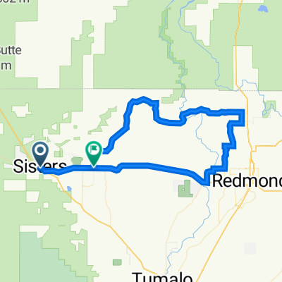
- Sisters to Smith rocks loop
- Distance
- 74.1 km
- Ascent
- 451 m
- Descent
- 483 m
- Location
- Sisters, Oregon, United States of America
- Sisters to Smith Rock
- Distance
- 59.1 km
- Ascent
- 222 m
- Descent
- 326 m
- Location
- Sisters, Oregon, United States of America
- West Jefferson Avenue 556, Sisters to West Jefferson Avenue 556, Sisters
- Distance
- 4.7 km
- Ascent
- 46 m
- Descent
- 42 m
- Location
- Sisters, Oregon, United States of America
- music to the train
- Distance
- 161.8 km
- Ascent
- 1,173 m
- Descent
- 694 m
- Location
- Sisters, Oregon, United States of America
Open it in the app