

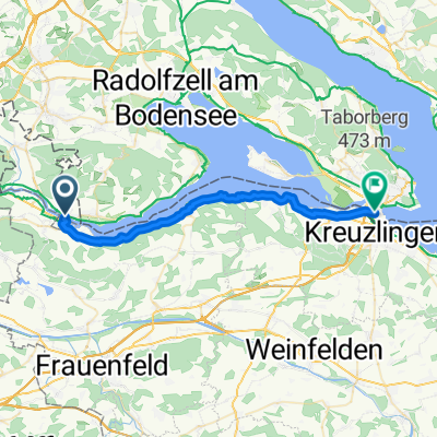
Chirchhofplatz 2, Stein am Rhein nach Karl-Wolf-Straße 2/3, Radolfzell am Bodensee
A cycling route starting in Stein am Rhein, Canton of Schaffhausen, Switzerland.
Overview
About this route
- 1 h 37 min
- Duration
- 24.5 km
- Distance
- 174 m
- Ascent
- 177 m
- Descent
- 15.1 km/h
- Avg. speed
- 442 m
- Max. altitude

Route quality
Waytypes & surfaces along the route
Waytypes
Path
7.4 km
(30 %)
Quiet road
6.1 km
(25 %)
Surfaces
Paved
20.3 km
(83 %)
Unpaved
4.2 km
(17 %)
Asphalt
20.3 km
(83 %)
Gravel
3.2 km
(13 %)
Continue with Bikemap
Use, edit, or download this cycling route
You would like to ride Chirchhofplatz 2, Stein am Rhein nach Karl-Wolf-Straße 2/3, Radolfzell am Bodensee or customize it for your own trip? Here is what you can do with this Bikemap route:
Free features
- Save this route as favorite or in collections
- Copy & plan your own version of this route
- Sync your route with Garmin or Wahoo
Premium features
Free trial for 3 days, or one-time payment. More about Bikemap Premium.
- Navigate this route on iOS & Android
- Export a GPX / KML file of this route
- Create your custom printout (try it for free)
- Download this route for offline navigation
Discover more Premium features.
Get Bikemap PremiumFrom our community
Other popular routes starting in Stein am Rhein
 Hemmenhofen Schaffhausen und zurück
- Distance
- 62.8 km
- Ascent
- 191 m
- Descent
- 191 m
- Location
- Stein am Rhein, Canton of Schaffhausen, Switzerland
 Vom Bodensee zur Nordsee
- Distance
- 1,086.3 km
- Ascent
- 69 m
- Descent
- 462 m
- Location
- Stein am Rhein, Canton of Schaffhausen, Switzerland
 Rheinfall
- Distance
- 25.3 km
- Ascent
- 170 m
- Descent
- 174 m
- Location
- Stein am Rhein, Canton of Schaffhausen, Switzerland
 Rund um den Bodensee
- Distance
- 239.4 km
- Ascent
- 247 m
- Descent
- 250 m
- Location
- Stein am Rhein, Canton of Schaffhausen, Switzerland
 Rathausplatz 7, Stein am Rhein to Rümikerstrasse 50, Winterthur
- Distance
- 28 km
- Ascent
- 331 m
- Descent
- 262 m
- Location
- Stein am Rhein, Canton of Schaffhausen, Switzerland
 Rathausplatz 11, Stein am Rhein nach St-Stephans-Platz 15, Konstanz
- Distance
- 28.7 km
- Ascent
- 313 m
- Descent
- 308 m
- Location
- Stein am Rhein, Canton of Schaffhausen, Switzerland
 Obergass nach Untere Laube
- Distance
- 29.1 km
- Ascent
- 367 m
- Descent
- 368 m
- Location
- Stein am Rhein, Canton of Schaffhausen, Switzerland
 Kreuzlingen-Hafen nach Stein am Rhein
- Distance
- 30.3 km
- Ascent
- 56 m
- Descent
- 52 m
- Location
- Stein am Rhein, Canton of Schaffhausen, Switzerland
Open it in the app