
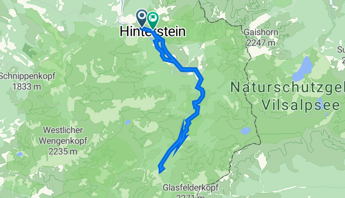
Hinterstein Bäckerei Weber - Bad Hindelang nach Auf dem Buck 3, Bad Hindelang
A cycling route starting in Sonthofen, Bavaria, Germany.
Overview
About this route
- 3 h 45 min
- Duration
- 22.5 km
- Distance
- 236 m
- Ascent
- 227 m
- Descent
- 6 km/h
- Avg. speed
- 1,068 m
- Avg. speed

Route quality
Waytypes & surfaces along the route
Waytypes
Quiet road
18 km
(80 %)
Road
2.2 km
(10 %)
Surfaces
Paved
21.2 km
(95 %)
Unpaved
1.2 km
(5 %)
Asphalt
21.2 km
(95 %)
Loose gravel
0.9 km
(4 %)
Continue with Bikemap
Use, edit, or download this cycling route
You would like to ride Hinterstein Bäckerei Weber - Bad Hindelang nach Auf dem Buck 3, Bad Hindelang or customize it for your own trip? Here is what you can do with this Bikemap route:
Free features
- Save this route as favorite or in collections
- Copy & plan your own version of this route
- Sync your route with Garmin or Wahoo
Premium features
Free trial for 3 days, or one-time payment. More about Bikemap Premium.
- Navigate this route on iOS & Android
- Export a GPX / KML file of this route
- Create your custom printout (try it for free)
- Download this route for offline navigation
Discover more Premium features.
Get Bikemap PremiumFrom our community
Other popular routes starting in Sonthofen
 D_SüdBayern_Sonthofen: "Allgaeu Panorama Marathon"
- Distance
- 41.5 km
- Ascent
- 1,134 m
- Descent
- 1,133 m
- Location
- Sonthofen, Bavaria, Germany
 Dreiangelhütte
- Distance
- 25.4 km
- Ascent
- 722 m
- Descent
- 728 m
- Location
- Sonthofen, Bavaria, Germany
 Wertach Runde
- Distance
- 44.6 km
- Ascent
- 561 m
- Descent
- 562 m
- Location
- Sonthofen, Bavaria, Germany
 Sonthofen-Oberstdorf
- Distance
- 32 km
- Ascent
- 76 m
- Descent
- 76 m
- Location
- Sonthofen, Bavaria, Germany
 Allgäu-Oberjoch-Tannheimer Tal
- Distance
- 87.4 km
- Ascent
- 953 m
- Descent
- 953 m
- Location
- Sonthofen, Bavaria, Germany
 Zweite Runde 14.05.2025 16:43:29
- Distance
- 15.5 km
- Ascent
- 101 m
- Descent
- 100 m
- Location
- Sonthofen, Bavaria, Germany
 einfache Talrunde (mit Altst.-Hof)
- Distance
- 33.7 km
- Ascent
- 824 m
- Descent
- 821 m
- Location
- Sonthofen, Bavaria, Germany
 12.05.2025 15:18:28
- Distance
- 19 km
- Ascent
- 110 m
- Descent
- 109 m
- Location
- Sonthofen, Bavaria, Germany
Open it in the app