

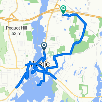
GLP 40min
A cycling route starting in Mystic, Connecticut, United States.
Overview
About this route
- 48 min
- Duration
- 14.1 km
- Distance
- 102 m
- Ascent
- 112 m
- Descent
- 17.7 km/h
- Avg. speed
- 26 m
- Max. altitude

Route quality
Waytypes & surfaces along the route
Waytypes
Quiet road
4.5 km
(32 %)
Access road
0.4 km
(3 %)
Surfaces
Paved
0.4 km
(3 %)
Asphalt
0.4 km
(3 %)
Undefined
13.6 km
(97 %)
Continue with Bikemap
Use, edit, or download this cycling route
You would like to ride GLP 40min or customize it for your own trip? Here is what you can do with this Bikemap route:
Free features
- Save this route as favorite or in collections
- Copy & plan your own version of this route
- Sync your route with Garmin or Wahoo
Premium features
Free trial for 3 days, or one-time payment. More about Bikemap Premium.
- Navigate this route on iOS & Android
- Export a GPX / KML file of this route
- Create your custom printout (try it for free)
- Download this route for offline navigation
Discover more Premium features.
Get Bikemap PremiumFrom our community
Other popular routes starting in Mystic
 GLP 40min
- Distance
- 14.1 km
- Ascent
- 102 m
- Descent
- 112 m
- Location
- Mystic, Connecticut, United States
 200–298 Allyn St, Mystic to 15 Old Colony Ln, Ledyard
- Distance
- 11.6 km
- Ascent
- 130 m
- Descent
- 133 m
- Location
- Mystic, Connecticut, United States
 21 Godfrey St, Mystic to 1382–1398 RT-12, Gales Ferry
- Distance
- 13 km
- Ascent
- 136 m
- Descent
- 153 m
- Location
- Mystic, Connecticut, United States
 FPL noank
- Distance
- 25.1 km
- Ascent
- 46 m
- Descent
- 95 m
- Location
- Mystic, Connecticut, United States
 Bruggeman Pl, Mystic to Mystic
- Distance
- 15.8 km
- Ascent
- 110 m
- Descent
- 106 m
- Location
- Mystic, Connecticut, United States
 17 Water St, New London to 31 Water St, New London
- Distance
- 45.6 km
- Ascent
- 410 m
- Descent
- 412 m
- Location
- Mystic, Connecticut, United States
 Gallup Hill Loop
- Distance
- 34.7 km
- Ascent
- 258 m
- Descent
- 258 m
- Location
- Mystic, Connecticut, United States
 20 Mile Road Ride
- Distance
- 31.8 km
- Ascent
- 108 m
- Descent
- 110 m
- Location
- Mystic, Connecticut, United States
Open it in the app