
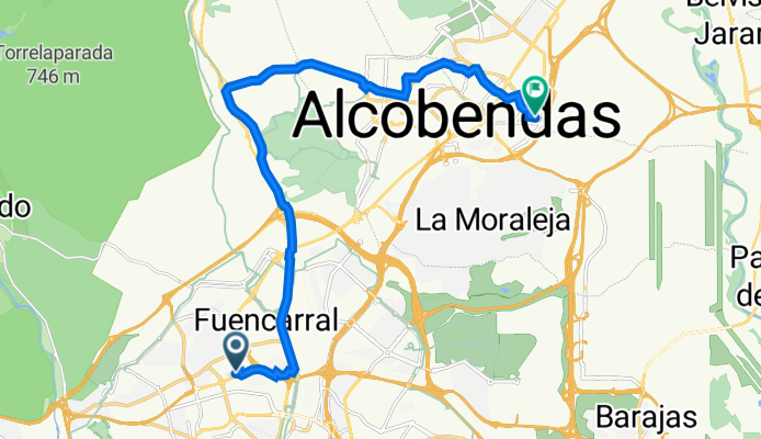
De Calle de Santiago de Compostela 28, Madrid a Avenida del Juncal 15, San Sebastián de los Reyes
A cycling route starting in Tetuán de las Victorias, Madrid, Spain.
Overview
About this route
- 1 h 18 min
- Duration
- 19.2 km
- Distance
- 126 m
- Ascent
- 190 m
- Descent
- 14.9 km/h
- Avg. speed
- 754 m
- Avg. speed
Route quality
Waytypes & surfaces along the route
Waytypes
Cycleway
9.2 km
(48 %)
Quiet road
4.7 km
(25 %)
Surfaces
Paved
8.3 km
(43 %)
Unpaved
0.1 km
(<1 %)
Asphalt
7.4 km
(38 %)
Concrete
0.9 km
(4 %)
Continue with Bikemap
Use, edit, or download this cycling route
You would like to ride De Calle de Santiago de Compostela 28, Madrid a Avenida del Juncal 15, San Sebastián de los Reyes or customize it for your own trip? Here is what you can do with this Bikemap route:
Free features
- Save this route as favorite or in collections
- Copy & plan your own version of this route
- Sync your route with Garmin or Wahoo
Premium features
Free trial for 3 days, or one-time payment. More about Bikemap Premium.
- Navigate this route on iOS & Android
- Export a GPX / KML file of this route
- Create your custom printout (try it for free)
- Download this route for offline navigation
Discover more Premium features.
Get Bikemap PremiumFrom our community
Other popular routes starting in Tetuán de las Victorias
 Brevet Randonneur 300K CC Chamartín 2017
- Distance
- 305.8 km
- Ascent
- 2,184 m
- Descent
- 2,181 m
- Location
- Tetuán de las Victorias, Madrid, Spain
 Brevet Randonneur 400K CC Chamartín 2017
- Distance
- 419.9 km
- Ascent
- 2,502 m
- Descent
- 3,202 m
- Location
- Tetuán de las Victorias, Madrid, Spain
 Casa Campo1
- Distance
- 11 km
- Ascent
- 24 m
- Descent
- 103 m
- Location
- Tetuán de las Victorias, Madrid, Spain
 lunes por la casa de campo
- Distance
- 44.2 km
- Ascent
- 1,767 m
- Descent
- 1,682 m
- Location
- Tetuán de las Victorias, Madrid, Spain
 Anillo Verde 2019 (acortando por Madrid Río)
- Distance
- 51.7 km
- Ascent
- 381 m
- Descent
- 1,003 m
- Location
- Tetuán de las Victorias, Madrid, Spain
 usera
usera- Distance
- 16.2 km
- Ascent
- 40 m
- Descent
- 155 m
- Location
- Tetuán de las Victorias, Madrid, Spain
 Dehesa de la Villa-Pozuelo Estación
- Distance
- 9.2 km
- Ascent
- 90 m
- Descent
- 91 m
- Location
- Tetuán de las Victorias, Madrid, Spain
 Ruta a la entrada de El Pardo
- Distance
- 16 km
- Ascent
- 160 m
- Descent
- 158 m
- Location
- Tetuán de las Victorias, Madrid, Spain
Open it in the app