

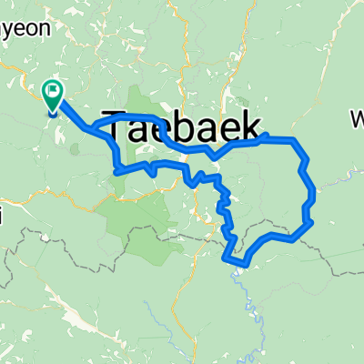
운탄고도 만항재-예미역
A cycling route starting in T’aebaek, Gangwon-do, South Korea.
Overview
About this route
Bientus, Inc. - www.ramblr.com - Share your outdoor stories on a map!
- -:--
- Duration
- 39.3 km
- Distance
- 916 m
- Ascent
- 1,706 m
- Descent
- ---
- Avg. speed
- 1,287 m
- Max. altitude

Route quality
Waytypes & surfaces along the route
Waytypes
Track
32.6 km
(83 %)
Quiet road
4.7 km
(12 %)
Access road
2 km
(5 %)
Surfaces
Paved
9.4 km
(24 %)
Unpaved
29.9 km
(76 %)
Gravel
15.7 km
(40 %)
Unpaved (undefined)
14.2 km
(36 %)
Continue with Bikemap
Use, edit, or download this cycling route
You would like to ride 운탄고도 만항재-예미역 or customize it for your own trip? Here is what you can do with this Bikemap route:
Free features
- Save this route as favorite or in collections
- Copy & plan your own version of this route
- Sync your route with Garmin or Wahoo
Premium features
Free trial for 3 days, or one-time payment. More about Bikemap Premium.
- Navigate this route on iOS & Android
- Export a GPX / KML file of this route
- Create your custom printout (try it for free)
- Download this route for offline navigation
Discover more Premium features.
Get Bikemap PremiumFrom our community
Other popular routes starting in T’aebaek
 Day3_1
- Distance
- 113.3 km
- Ascent
- 2,202 m
- Descent
- 2,204 m
- Location
- T’aebaek, Gangwon-do, South Korea
 서학로, 태백시 to 사북읍 산153-18, 정선군
- Distance
- 81.1 km
- Ascent
- 966 m
- Descent
- 1,366 m
- Location
- T’aebaek, Gangwon-do, South Korea
 정선군에서 정선군까지
- Distance
- 64 km
- Ascent
- 1,985 m
- Descent
- 1,989 m
- Location
- T’aebaek, Gangwon-do, South Korea
![고한읍Ph0]으로 라우팅](https://media.bikemap.net/routes/17602943/staticmaps/in_5ec2fe13-4cce-4f78-9a40-8c23240e76c8_400x400_bikemap-2021-3D-static.png) 고한읍Ph0]으로 라우팅
고한읍Ph0]으로 라우팅- Distance
- 6.2 km
- Ascent
- 25 m
- Descent
- 451 m
- Location
- T’aebaek, Gangwon-do, South Korea
 강원랜드-두문동재-석개재-만항재-강원랜드
- Distance
- 118.3 km
- Ascent
- 2,676 m
- Descent
- 2,639 m
- Location
- T’aebaek, Gangwon-do, South Korea
 운탄고도 만항재-예미역
- Distance
- 39.3 km
- Ascent
- 916 m
- Descent
- 1,706 m
- Location
- T’aebaek, Gangwon-do, South Korea
 Day3_2
- Distance
- 47.9 km
- Ascent
- 1,127 m
- Descent
- 1,129 m
- Location
- T’aebaek, Gangwon-do, South Korea
 113
113- Distance
- 20.7 km
- Ascent
- 1,047 m
- Descent
- 486 m
- Location
- T’aebaek, Gangwon-do, South Korea
Open it in the app