
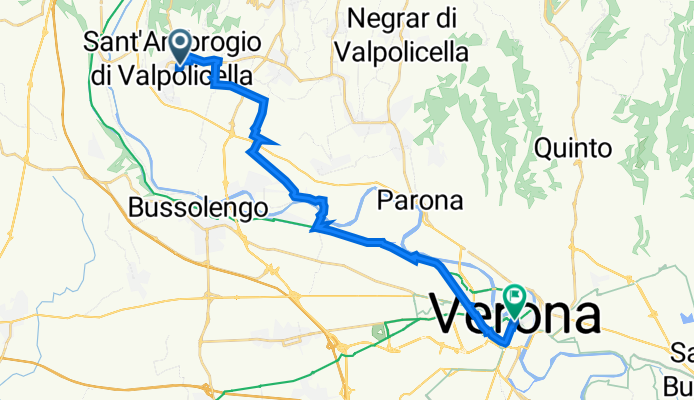
Sant'Ambrogio di Valpolicella nach Via degli Alpini 97, Verona
A cycling route starting in Sant'Ambrogio di Valpolicella, Veneto, Italy.
Overview
About this route
- 1 h 21 min
- Duration
- 21.4 km
- Distance
- 53 m
- Ascent
- 143 m
- Descent
- 15.9 km/h
- Avg. speed
- 160 m
- Max. altitude
Route quality
Waytypes & surfaces along the route
Waytypes
Cycleway
6.3 km
(29 %)
Road
6.3 km
(29 %)
Surfaces
Paved
17.8 km
(83 %)
Unpaved
2.9 km
(14 %)
Asphalt
17.1 km
(80 %)
Unpaved (undefined)
2.2 km
(10 %)
Continue with Bikemap
Use, edit, or download this cycling route
You would like to ride Sant'Ambrogio di Valpolicella nach Via degli Alpini 97, Verona or customize it for your own trip? Here is what you can do with this Bikemap route:
Free features
- Save this route as favorite or in collections
- Copy & plan your own version of this route
- Sync your route with Garmin or Wahoo
Premium features
Free trial for 3 days, or one-time payment. More about Bikemap Premium.
- Navigate this route on iOS & Android
- Export a GPX / KML file of this route
- Create your custom printout (try it for free)
- Download this route for offline navigation
Discover more Premium features.
Get Bikemap PremiumFrom our community
Other popular routes starting in Sant'Ambrogio di Valpolicella
 PERCORSO DELLE TRE VALLI
- Distance
- 33.2 km
- Ascent
- 766 m
- Descent
- 747 m
- Location
- Sant'Ambrogio di Valpolicella, Veneto, Italy
 san Giorgio in Valpolicella
- Distance
- 5.4 km
- Ascent
- 425 m
- Descent
- 434 m
- Location
- Sant'Ambrogio di Valpolicella, Veneto, Italy
 DORSALE DEL GARDA
- Distance
- 26.3 km
- Ascent
- 343 m
- Descent
- 298 m
- Location
- Sant'Ambrogio di Valpolicella, Veneto, Italy
 Italy 5a. Sant Ambroglio di Valpolicella to Pescantini
- Distance
- 36.9 km
- Ascent
- 953 m
- Descent
- 966 m
- Location
- Sant'Ambrogio di Valpolicella, Veneto, Italy
 PERCORSO DELLE TRE VALLI
- Distance
- 32.8 km
- Ascent
- 759 m
- Descent
- 733 m
- Location
- Sant'Ambrogio di Valpolicella, Veneto, Italy
 5/2022 Domegliara - Roncegno
- Distance
- 111.3 km
- Ascent
- 220 m
- Descent
- 324 m
- Location
- Sant'Ambrogio di Valpolicella, Veneto, Italy
 Sant'Ambrogio Valpolicella-fosse
- Distance
- 57.9 km
- Ascent
- 1,018 m
- Descent
- 1,024 m
- Location
- Sant'Ambrogio di Valpolicella, Veneto, Italy
 In MTB da Gargagnago a Monte
- Distance
- 23.3 km
- Ascent
- 838 m
- Descent
- 837 m
- Location
- Sant'Ambrogio di Valpolicella, Veneto, Italy
Open it in the app