

Bethesda - Smithsonian
A cycling route starting in Bethesda, Maryland, United States.
Overview
About this route
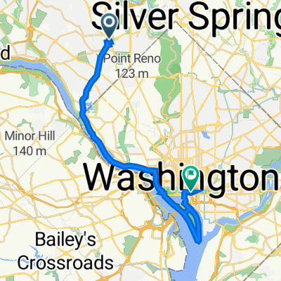
Bethesda to the National Mall with optional loop through East Potomac Park
- -:--
- Duration
- 24.9 km
- Distance
- 136 m
- Ascent
- 236 m
- Descent
- ---
- Avg. speed
- 113 m
- Max. altitude

Continue with Bikemap
Use, edit, or download this cycling route
You would like to ride Bethesda - Smithsonian or customize it for your own trip? Here is what you can do with this Bikemap route:
Free features
- Save this route as favorite or in collections
- Copy & plan your own version of this route
- Sync your route with Garmin or Wahoo
Premium features
Free trial for 3 days, or one-time payment. More about Bikemap Premium.
- Navigate this route on iOS & Android
- Export a GPX / KML file of this route
- Create your custom printout (try it for free)
- Download this route for offline navigation
Discover more Premium features.
Get Bikemap PremiumFrom our community
Other popular routes starting in Bethesda
 2020-08-02
- Distance
- 26.9 km
- Ascent
- 181 m
- Descent
- 184 m
- Location
- Bethesda, Maryland, United States
 Twinbrook Loop
- Distance
- 25.5 km
- Ascent
- 160 m
- Descent
- 161 m
- Location
- Bethesda, Maryland, United States
 Woodmont Avenue to Nebraska Avenue Northwest
- Distance
- 12.7 km
- Ascent
- 141 m
- Descent
- 178 m
- Location
- Bethesda, Maryland, United States
 Long ride from Chevy Chase to Silver Spring
- Distance
- 52 km
- Ascent
- 227 m
- Descent
- 239 m
- Location
- Bethesda, Maryland, United States
 Diego's route
- Distance
- 46.6 km
- Ascent
- 318 m
- Descent
- 310 m
- Location
- Bethesda, Maryland, United States
 Bethesda - Smithsonian
- Distance
- 24.9 km
- Ascent
- 136 m
- Descent
- 236 m
- Location
- Bethesda, Maryland, United States
 Cabin John/C&O/Capitol Crescent
- Distance
- 33.4 km
- Ascent
- 172 m
- Descent
- 181 m
- Location
- Bethesda, Maryland, United States
 EYP Detailed Bike Route
- Distance
- 67.6 km
- Ascent
- 674 m
- Descent
- 672 m
- Location
- Bethesda, Maryland, United States
Open it in the app