

Gota Kanal 4a tappa: Vreta - Soderkoping
A cycling route starting in Olstorp, Södermanland County, Sweden.
Overview
About this route
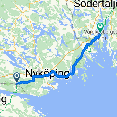
- Tuesday, August 12, 2008 - 4th Stage: 2nd stage Giro Gota KanalVreta - SoderkopingNice weather and breezyDeparture from Vreta at 9:15 after the usual hearty breakfast and under a beautiful sun with a bit of wind. Always following the Nackrosleden, after a couple of km on the national road we turn right, tackle a small hill and pass Alberga. Continuing on asphalt, the Nackrosleden reaches Kvarsebo and a large fjord on the Baltic, which we follow for a couple of km to the right until the free ferry that connects the continuation of the road south. Once ferried, our challenge will be to fight against a blazing sun and a strong headwind for over 20 km traversing O Husby and Kuddy. One km after Kuddy, the Nackrosleden takes us to the left on a dirt road until the village of Mem. After passing the castle, we descend to the seaside with a beautiful beach where the Gota Kanal flows into the Baltic. Time for food and a good coffee with some photos at the lock of the canal and then we climb the bank following the bike path of the Langs Gota Kanal to Soderkoping.
- -:--
- Duration
- 50.3 km
- Distance
- 211 m
- Ascent
- 256 m
- Descent
- ---
- Avg. speed
- ---
- Max. altitude

Route quality
Waytypes & surfaces along the route
Waytypes
Road
39.2 km
(78 %)
Path
5.5 km
(11 %)
Surfaces
Paved
38.7 km
(77 %)
Unpaved
7.5 km
(15 %)
Asphalt
38.7 km
(77 %)
Gravel
7.5 km
(15 %)
Undefined
4 km
(8 %)
Continue with Bikemap
Use, edit, or download this cycling route
You would like to ride Gota Kanal 4a tappa: Vreta - Soderkoping or customize it for your own trip? Here is what you can do with this Bikemap route:
Free features
- Save this route as favorite or in collections
- Copy & plan your own version of this route
- Sync your route with Garmin or Wahoo
Premium features
Free trial for 3 days, or one-time payment. More about Bikemap Premium.
- Navigate this route on iOS & Android
- Export a GPX / KML file of this route
- Create your custom printout (try it for free)
- Download this route for offline navigation
Discover more Premium features.
Get Bikemap PremiumFrom our community
Other popular routes starting in Olstorp
 Bettna
- Distance
- 50.1 km
- Ascent
- 817 m
- Descent
- 812 m
- Location
- Olstorp, Södermanland County, Sweden
 Olstorp - Vagnhärad
- Distance
- 68.2 km
- Ascent
- 573 m
- Descent
- 584 m
- Location
- Olstorp, Södermanland County, Sweden
 Olstorp - Söderköping
- Distance
- 47.4 km
- Ascent
- 329 m
- Descent
- 382 m
- Location
- Olstorp, Södermanland County, Sweden
 Olstorp - Linghem
- Distance
- 73.7 km
- Ascent
- 451 m
- Descent
- 483 m
- Location
- Olstorp, Södermanland County, Sweden
 Olstorp - Vagnhärad
- Distance
- 92.3 km
- Ascent
- 69 m
- Descent
- 93 m
- Location
- Olstorp, Södermanland County, Sweden
 Gota Kanal 4a tappa: Vreta - Soderkoping
- Distance
- 50.3 km
- Ascent
- 211 m
- Descent
- 256 m
- Location
- Olstorp, Södermanland County, Sweden
 Viby-Bettna-Vrena
- Distance
- 21.4 km
- Ascent
- 140 m
- Descent
- 146 m
- Location
- Olstorp, Södermanland County, Sweden
 Slow ride in Åby
- Distance
- 31.8 km
- Ascent
- 261 m
- Descent
- 340 m
- Location
- Olstorp, Södermanland County, Sweden
Open it in the app