
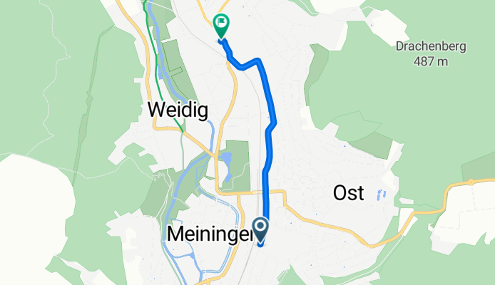
Berliner Straße 8, Meiningen nach Leipziger Straße 70, Meiningen
A cycling route starting in Meiningen, Free State of Thuringia, Germany.
Overview
About this route
- 5 min
- Duration
- 2.2 km
- Distance
- 15 m
- Ascent
- 27 m
- Descent
- 25.7 km/h
- Avg. speed
- 319 m
- Max. altitude

Continue with Bikemap
Use, edit, or download this cycling route
You would like to ride Berliner Straße 8, Meiningen nach Leipziger Straße 70, Meiningen or customize it for your own trip? Here is what you can do with this Bikemap route:
Free features
- Save this route as favorite or in collections
- Copy & plan your own version of this route
- Sync your route with Garmin or Wahoo
Premium features
Free trial for 3 days, or one-time payment. More about Bikemap Premium.
- Navigate this route on iOS & Android
- Export a GPX / KML file of this route
- Create your custom printout (try it for free)
- Download this route for offline navigation
Discover more Premium features.
Get Bikemap PremiumFrom our community
Other popular routes starting in Meiningen
 067 Zipfeltour2013 Tag07 Meiningen-Ruhla
- Distance
- 57.9 km
- Ascent
- 504 m
- Descent
- 466 m
- Location
- Meiningen, Free State of Thuringia, Germany
 2025-05-09_Meinigen-Werra-Obersuhl
- Distance
- 85.6 km
- Ascent
- 503 m
- Descent
- 577 m
- Location
- Meiningen, Free State of Thuringia, Germany
 Werra 2009
- Distance
- 228.4 km
- Ascent
- 982 m
- Descent
- 1,118 m
- Location
- Meiningen, Free State of Thuringia, Germany
 MGN-MET-Völk*hsn-MGN-FEB21
- Distance
- 53.5 km
- Ascent
- 378 m
- Descent
- 369 m
- Location
- Meiningen, Free State of Thuringia, Germany
 MGN - Dreißigacker - Sülzfeld - Fasanerie - MGN
- Distance
- 29.7 km
- Ascent
- 331 m
- Descent
- 338 m
- Location
- Meiningen, Free State of Thuringia, Germany
 Gruenes Band 23
- Distance
- 238.3 km
- Ascent
- 2,989 m
- Descent
- 2,799 m
- Location
- Meiningen, Free State of Thuringia, Germany
 MGN-Hohe Mass-Helehenhöe-MGN
- Distance
- 15.7 km
- Ascent
- 274 m
- Descent
- 275 m
- Location
- Meiningen, Free State of Thuringia, Germany
 Meiningen/Werra nach Bad Kissingen/Rhön CLONED FROM ROUTE 1904
- Distance
- 68.2 km
- Ascent
- 312 m
- Descent
- 397 m
- Location
- Meiningen, Free State of Thuringia, Germany
Open it in the app