

운교동 167-4, 춘천시 ~ 교동 136-13, 춘천시
A cycling route starting in Chuncheon, Gangwon-do, South Korea.
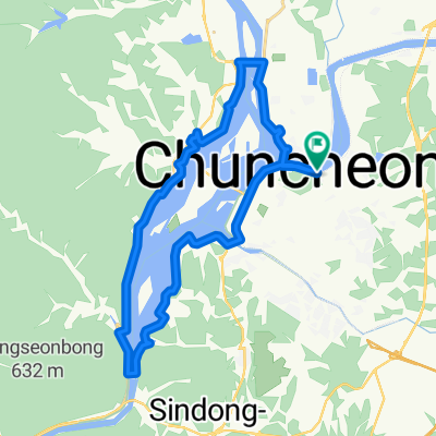
Overview
About this route
- 2 h 8 min
- Duration
- 30.5 km
- Distance
- 116 m
- Ascent
- 108 m
- Descent
- 14.3 km/h
- Avg. speed
- 112 m
- Max. altitude

Route photos


Continue with Bikemap
Use, edit, or download this cycling route
You would like to ride 운교동 167-4, 춘천시 ~ 교동 136-13, 춘천시 or customize it for your own trip? Here is what you can do with this Bikemap route:
Free features
- Save this route as favorite or in collections
- Copy & plan your own version of this route
- Sync your route with Garmin or Wahoo
Premium features
Free trial for 3 days, or one-time payment. More about Bikemap Premium.
- Navigate this route on iOS & Android
- Export a GPX / KML file of this route
- Create your custom printout (try it for free)
- Download this route for offline navigation
Discover more Premium features.
Get Bikemap PremiumFrom our community
Other popular routes starting in Chuncheon
 북한강 춘천~동서울
- Distance
- 111 km
- Ascent
- 1,108 m
- Descent
- 1,167 m
- Location
- Chuncheon, Gangwon-do, South Korea
 춘천역 - 당산역
- Distance
- 127.7 km
- Ascent
- 1,449 m
- Descent
- 1,504 m
- Location
- Chuncheon, Gangwon-do, South Korea
 춘천-배후령-하나로 간동면-파로호-화천읍-부다리-하나로 고탄리-세미고개-춘천
- Distance
- 84.4 km
- Ascent
- 1,874 m
- Descent
- 1,870 m
- Location
- Chuncheon, Gangwon-do, South Korea
 근화동, 춘천시에서 근화동, 춘천시까지
- Distance
- 30.2 km
- Ascent
- 151 m
- Descent
- 146 m
- Location
- Chuncheon, Gangwon-do, South Korea
 의암댐라이딩
- Distance
- 29.6 km
- Ascent
- 115 m
- Descent
- 117 m
- Location
- Chuncheon, Gangwon-do, South Korea
 Chuncheon Circular RTC
- Distance
- 27.5 km
- Ascent
- 215 m
- Descent
- 221 m
- Location
- Chuncheon, Gangwon-do, South Korea
 춘천역-신매대교 인증센터
- Distance
- 6.7 km
- Ascent
- 19 m
- Descent
- 46 m
- Location
- Chuncheon, Gangwon-do, South Korea
 운교동 167-4, 춘천시 ~ 교동 136-13, 춘천시
- Distance
- 30.5 km
- Ascent
- 116 m
- Descent
- 108 m
- Location
- Chuncheon, Gangwon-do, South Korea
Open it in the app