

elan avitan
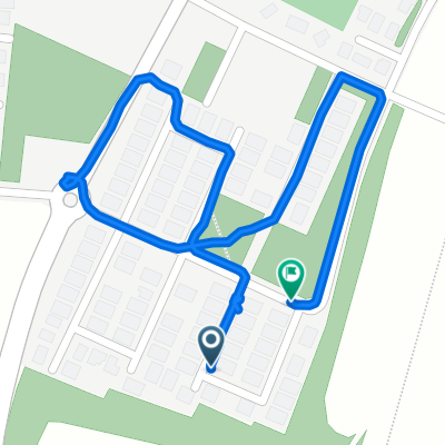
A cycling route starting in Far‘ūn, West Bank, Palestine.
Overview
About this route
- 29 min
- Duration
- 6.1 km
- Distance
- 62 m
- Ascent
- 55 m
- Descent
- 12.5 km/h
- Avg. speed
- 57 m
- Max. altitude
Route photos

Continue with Bikemap
Use, edit, or download this cycling route
You would like to ride elan avitan or customize it for your own trip? Here is what you can do with this Bikemap route:
Free features
- Save this route as favorite or in collections
- Copy & plan your own version of this route
- Sync your route with Garmin or Wahoo
Premium features
Free trial for 3 days, or one-time payment. More about Bikemap Premium.
- Navigate this route on iOS & Android
- Export a GPX / KML file of this route
- Create your custom printout (try it for free)
- Download this route for offline navigation
Discover more Premium features.
Get Bikemap PremiumFrom our community
Other popular routes starting in Far‘ūn
 Sderot Oved Ben Ami 71, Netanya to Khatsav Street 16, Even Yehuda
- Distance
- 8.1 km
- Ascent
- 35 m
- Descent
- 24 m
- Location
- Far‘ūn, West Bank, Palestine
 אלנור, טייבה to אלנור, טייבה
- Distance
- 89.3 km
- Ascent
- 362 m
- Descent
- 339 m
- Location
- Far‘ūn, West Bank, Palestine
 בת חפר
- Distance
- 6.8 km
- Ascent
- 34 m
- Descent
- 25 m
- Location
- Far‘ūn, West Bank, Palestine
 רופין
רופין- Distance
- 16.9 km
- Ascent
- 60 m
- Descent
- 89 m
- Location
- Far‘ūn, West Bank, Palestine
 Steady ride
- Distance
- 1.7 km
- Ascent
- 0 m
- Descent
- 32 m
- Location
- Far‘ūn, West Bank, Palestine
 הנופר 35, שער אפרים to אל קודס 27, קלנסווה
- Distance
- 2.1 km
- Ascent
- 0 m
- Descent
- 4 m
- Location
- Far‘ūn, West Bank, Palestine
 נחל אלכסנדר 24ק, 0מ
- Distance
- 24.2 km
- Ascent
- 13 m
- Descent
- 50 m
- Location
- Far‘ūn, West Bank, Palestine
 elan avitan
- Distance
- 6.1 km
- Ascent
- 62 m
- Descent
- 55 m
- Location
- Far‘ūn, West Bank, Palestine
Open it in the app