

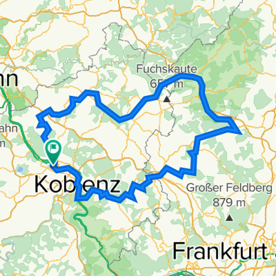
Bassenheim-Runde ab NR 43km 450Hm
A cycling route starting in Weißenthurm, Rhineland-Palatinate, Germany.
Overview
About this route
Start in NR, Rheinbrücke-Weißenthurm-Kettig-Kärlich-Bassenheim mit Biergarten Zum Hirsch oder Schloßklause-Abstecher zum Naturdenkmal Baumallee-Unterquerung A48 und A61-herrlicher Weg mit langem Gefälle nach Rübenach, durch Friedhof-Siedlung, entlang A48- Überquerung A48-Depot-Mülheim-Urmitz Bhf-Rheinufer-Radweg-Weißenthurm-Rheinbrücke
- -:--
- Duration
- 38.9 km
- Distance
- 488 m
- Ascent
- 491 m
- Descent
- ---
- Avg. speed
- 295 m
- Max. altitude
Route quality
Waytypes & surfaces along the route
Waytypes
Quiet road
13.1 km
(34 %)
Track
11.3 km
(29 %)
Surfaces
Paved
24.8 km
(64 %)
Unpaved
4.5 km
(11 %)
Asphalt
15.6 km
(40 %)
Paved (undefined)
5.2 km
(13 %)
Continue with Bikemap
Use, edit, or download this cycling route
You would like to ride Bassenheim-Runde ab NR 43km 450Hm or customize it for your own trip? Here is what you can do with this Bikemap route:
Free features
- Save this route as favorite or in collections
- Copy & plan your own version of this route
- Sync your route with Garmin or Wahoo
Premium features
Free trial for 3 days, or one-time payment. More about Bikemap Premium.
- Navigate this route on iOS & Android
- Export a GPX / KML file of this route
- Create your custom printout (try it for free)
- Download this route for offline navigation
Discover more Premium features.
Get Bikemap PremiumFrom our community
Other popular routes starting in Weißenthurm
 Wiedtal/Westerwald
- Distance
- 81.8 km
- Ascent
- 973 m
- Descent
- 856 m
- Location
- Weißenthurm, Rhineland-Palatinate, Germany
 Pegelturm_Andern_Fähre Breisig_Arenfels-Runde 38km
- Distance
- 38 km
- Ascent
- 163 m
- Descent
- 157 m
- Location
- Weißenthurm, Rhineland-Palatinate, Germany
 Koblenz,56575 Weißenthurm 32, Bahnhofstrasse
- Distance
- 39 km
- Ascent
- 50 m
- Descent
- 50 m
- Location
- Weißenthurm, Rhineland-Palatinate, Germany
 Westerwald-Lahn-Tour
- Distance
- 316.1 km
- Ascent
- 4,177 m
- Descent
- 4,176 m
- Location
- Weißenthurm, Rhineland-Palatinate, Germany
 Weißenth_Mayen_Bassenheim-Rundtour
- Distance
- 57.9 km
- Ascent
- 370 m
- Descent
- 370 m
- Location
- Weißenthurm, Rhineland-Palatinate, Germany
 0111a Kruft Nickenich Eich
- Distance
- 34.1 km
- Ascent
- 261 m
- Descent
- 265 m
- Location
- Weißenthurm, Rhineland-Palatinate, Germany
 Nette-Obst-Radrunde ü. Plaidt45 km - Nette-Obst-Radrunde ü. Plaidt45 km
- Distance
- 44.6 km
- Ascent
- 228 m
- Descent
- 228 m
- Location
- Weißenthurm, Rhineland-Palatinate, Germany
 Nette-Obst-Radrunde ü. Plaidt45 km
- Distance
- 44.7 km
- Ascent
- 422 m
- Descent
- 422 m
- Location
- Weißenthurm, Rhineland-Palatinate, Germany
Open it in the app