
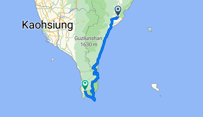
台東-太麻里(山)-旭海-墾丁-恆春
A cycling route starting in Taitung, Taiwan, Taiwan.
Overview
About this route
- -:--
- Duration
- 168.8 km
- Distance
- 1,126 m
- Ascent
- 1,146 m
- Descent
- ---
- Avg. speed
- ---
- Max. altitude

Continue with Bikemap
Use, edit, or download this cycling route
You would like to ride 台東-太麻里(山)-旭海-墾丁-恆春 or customize it for your own trip? Here is what you can do with this Bikemap route:
Free features
- Save this route as favorite or in collections
- Copy & plan your own version of this route
- Split it into stages to create a multi-day tour
- Sync your route with Garmin or Wahoo
Premium features
Free trial for 3 days, or one-time payment. More about Bikemap Premium.
- Navigate this route on iOS & Android
- Export a GPX / KML file of this route
- Create your custom printout (try it for free)
- Download this route for offline navigation
Discover more Premium features.
Get Bikemap PremiumFrom our community
Other popular routes starting in Taitung
 110.02.05台東-寒舍-山里-鹿野高台
- Distance
- 47.5 km
- Ascent
- 1,284 m
- Descent
- 932 m
- Location
- Taitung, Taiwan, Taiwan
 5. den. presun do Hualien.
- Distance
- 183.1 km
- Ascent
- 778 m
- Descent
- 743 m
- Location
- Taitung, Taiwan, Taiwan
 day11
day11- Distance
- 112.2 km
- Ascent
- 449 m
- Descent
- 529 m
- Location
- Taitung, Taiwan, Taiwan
 TW-209 台東瘋200K (伽路蘭)
- Distance
- 216.1 km
- Ascent
- 2,617 m
- Descent
- 2,610 m
- Location
- Taitung, Taiwan, Taiwan
 台東瘋200k
- Distance
- 214.4 km
- Ascent
- 2,545 m
- Descent
- 2,559 m
- Location
- Taitung, Taiwan, Taiwan
 2016轉大人花東單車趣_Day01
- Distance
- 45.4 km
- Ascent
- 439 m
- Descent
- 386 m
- Location
- Taitung, Taiwan, Taiwan
 寒舍+197鹿野回
- Distance
- 49.4 km
- Ascent
- 3,172 m
- Descent
- 3,134 m
- Location
- Taitung, Taiwan, Taiwan
 花東單車行(三天兩夜)
- Distance
- 251.2 km
- Ascent
- 1,219 m
- Descent
- 1,247 m
- Location
- Taitung, Taiwan, Taiwan
Open it in the app