

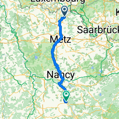
Day 3: CattenomSainte-Ruffine
A cycling route starting in Cattenom, Grand Est, France.
Overview
About this route
Cattenom, Thionville, Uckange, Metz, Sainte-Ruffine via La Voie Bleue
Overnight at La Maison Ruffinoise 4 Grand rue, 57130 Sainte-Ruffine, France
- -:--
- Duration
- 51.9 km
- Distance
- 378 m
- Ascent
- 169 m
- Descent
- ---
- Avg. speed
- 216 m
- Max. altitude

Route quality
Waytypes & surfaces along the route
Waytypes
Path
37.9 km
(73 %)
Quiet road
8 km
(15 %)
Surfaces
Paved
46.2 km
(89 %)
Unpaved
0.1 km
(<1 %)
Asphalt
44 km
(85 %)
Concrete
1.3 km
(3 %)
Continue with Bikemap
Use, edit, or download this cycling route
You would like to ride Day 3: CattenomSainte-Ruffine or customize it for your own trip? Here is what you can do with this Bikemap route:
Free features
- Save this route as favorite or in collections
- Copy & plan your own version of this route
- Sync your route with Garmin or Wahoo
Premium features
Free trial for 3 days, or one-time payment. More about Bikemap Premium.
- Navigate this route on iOS & Android
- Export a GPX / KML file of this route
- Create your custom printout (try it for free)
- Download this route for offline navigation
Discover more Premium features.
Get Bikemap PremiumFrom our community
Other popular routes starting in Cattenom
 Quick ride through Cattenom
- Distance
- 9.7 km
- Ascent
- 14 m
- Descent
- 16 m
- Location
- Cattenom, Grand Est, France
 Day 3: CattenomSainte-Ruffine
- Distance
- 51.9 km
- Ascent
- 378 m
- Descent
- 169 m
- Location
- Cattenom, Grand Est, France
 Tour Boler-Lux.-Rodemack
- Distance
- 21.9 km
- Ascent
- 209 m
- Descent
- 206 m
- Location
- Cattenom, Grand Est, France
 11–15 Rue des Vignes, Fixem à 56 Rue des Joncs, Beyren-lès-Sierck
- Distance
- 6.2 km
- Ascent
- 98 m
- Descent
- 83 m
- Location
- Cattenom, Grand Est, France
 DE BOUST A DUDELANGE
- Distance
- 51.8 km
- Ascent
- 328 m
- Descent
- 327 m
- Location
- Cattenom, Grand Est, France
 19bis Boucle d'Alsace-Lorraine, Cattenom à 136 Les Basses Terres, Manom
- Distance
- 11.2 km
- Ascent
- 0 m
- Descent
- 10 m
- Location
- Cattenom, Grand Est, France
 charles le temeraire
- Distance
- 157.4 km
- Ascent
- 157 m
- Descent
- 44 m
- Location
- Cattenom, Grand Est, France
 Von Cattenom bis Wasserliesch
- Distance
- 55.8 km
- Ascent
- 372 m
- Descent
- 355 m
- Location
- Cattenom, Grand Est, France
Open it in the app