

Airport to Harshaw Road loop and back to airport
A cycling route starting in Nogales, Arizona, United States of America.
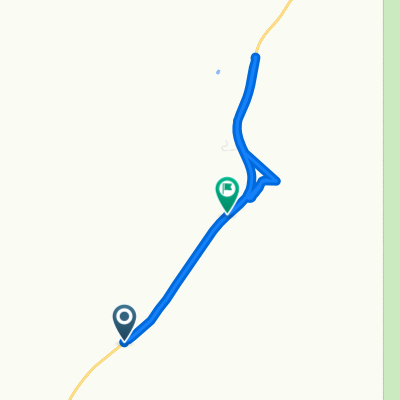
Overview
About this route
There are a couple of places to place a vehicle on this route to avoid having to ride the pavement back to the airport. This is a great ride, rugged in a few places andsome great climbs and downhills and well as some scenic detours. Bring plenty of water and snacks...it's a long ride.
- -:--
- Duration
- 28.4 km
- Distance
- 427 m
- Ascent
- 430 m
- Descent
- ---
- Avg. speed
- ---
- Avg. speed
Route highlights
Points of interest along the route
Point of interest after 2.7 km
Paloma Canyon Turnoff
Point of interest after 2.9 km
Point of interest after 2.9 km
Gate...Please close the gate...
Point of interest after 3.1 km
Junction..Right goes to old corrals and water tank and dead ends there...nice diversion..
Point of interest after 4.7 km
Gate..Please close the gate..
Point of interest after 4.7 km
This road just goes up the hill to a cattle tank and dead ends...it's still a good ride and a rugged climb
Point of interest after 7.7 km
Old Corral...this is a good turnaround spot if you want to go back the way you came..from here the round trip is 9.5 miles....or continue..
Point of interest after 8.7 km
great road...comes out just south of the runway...the gate is probably locked however
Point of interest after 9 km
Great climb and beautiful view from top but is a dead end..although the view is worth the ride
Point of interest after 12.8 km
Gate..Please close the gate
Point of interest after 14.9 km
This is a great place to leave a vehicle if you want to end your ride here..otherwise it's on out to the Patagonia Hwy
Point of interest after 15.9 km
Back entrance to Kino Springs via The Village
Point of interest after 23.1 km
this also a good place to leave a vehicle if you want to end the ride here...otherwise..back to the airport
Continue with Bikemap
Use, edit, or download this cycling route
You would like to ride Airport to Harshaw Road loop and back to airport or customize it for your own trip? Here is what you can do with this Bikemap route:
Free features
- Save this route as favorite or in collections
- Copy & plan your own version of this route
- Sync your route with Garmin or Wahoo
Premium features
Free trial for 3 days, or one-time payment. More about Bikemap Premium.
- Navigate this route on iOS & Android
- Export a GPX / KML file of this route
- Create your custom printout (try it for free)
- Download this route for offline navigation
Discover more Premium features.
Get Bikemap PremiumFrom our community
Other popular routes starting in Nogales
 744–748 E Patagonia Hwy, Nogales to 900–958 E Patagonia Hwy, Nogales
- Distance
- 7.9 km
- Ascent
- 1,279 m
- Descent
- 1,234 m
- Location
- Nogales, Arizona, United States of America
 san2tume
- Distance
- 828.7 km
- Ascent
- 2,759 m
- Descent
- 1,583 m
- Location
- Nogales, Arizona, United States of America
 paloma canyon
- Distance
- 14.9 km
- Ascent
- 333 m
- Descent
- 287 m
- Location
- Nogales, Arizona, United States of America
 trecho yankee
- Distance
- 3,675.7 km
- Ascent
- 9,362 m
- Descent
- 10,532 m
- Location
- Nogales, Arizona, United States of America
 Airport to Harshaw Road loop and back to airport
- Distance
- 28.4 km
- Ascent
- 427 m
- Descent
- 430 m
- Location
- Nogales, Arizona, United States of America
Open it in the app