

lehká roudnická
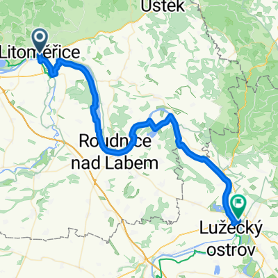
A cycling route starting in Litoměřice, Ústecký kraj, Czechia.
Overview
About this route
The more information you write here, the more useful it will be for other users.
- Route details.
- What is special about this route?
- Why recommend this route?
- What did you like most here?
- Etc.
- -:--
- Duration
- 45.6 km
- Distance
- 151 m
- Ascent
- 148 m
- Descent
- ---
- Avg. speed
- 195 m
- Max. altitude

Route quality
Waytypes & surfaces along the route
Waytypes
Road
12.3 km
(27 %)
Quiet road
5 km
(11 %)
Surfaces
Paved
14.1 km
(31 %)
Asphalt
14.1 km
(31 %)
Undefined
31.4 km
(69 %)
Continue with Bikemap
Use, edit, or download this cycling route
You would like to ride lehká roudnická or customize it for your own trip? Here is what you can do with this Bikemap route:
Free features
- Save this route as favorite or in collections
- Copy & plan your own version of this route
- Sync your route with Garmin or Wahoo
Premium features
Free trial for 3 days, or one-time payment. More about Bikemap Premium.
- Navigate this route on iOS & Android
- Export a GPX / KML file of this route
- Create your custom printout (try it for free)
- Download this route for offline navigation
Discover more Premium features.
Get Bikemap PremiumFrom our community
Other popular routes starting in Litoměřice
 Tyršův most, Litoměřice do Tyršův most, Litoměřice
- Distance
- 23.6 km
- Ascent
- 47 m
- Descent
- 42 m
- Location
- Litoměřice, Ústecký kraj, Czechia
 Ltm-Děčín-Ltm
- Distance
- 94 km
- Ascent
- 1,088 m
- Descent
- 1,034 m
- Location
- Litoměřice, Ústecký kraj, Czechia
 lehká roudnická
- Distance
- 45.6 km
- Ascent
- 151 m
- Descent
- 148 m
- Location
- Litoměřice, Ústecký kraj, Czechia
 Házmburk a Libochovice
- Distance
- 50.9 km
- Ascent
- 288 m
- Descent
- 288 m
- Location
- Litoměřice, Ústecký kraj, Czechia
 Tschechien nach náměstí Míru
- Distance
- 51.5 km
- Ascent
- 213 m
- Descent
- 163 m
- Location
- Litoměřice, Ústecký kraj, Czechia
 Vrchlického, Litoměřice to Hauptstraße, Bad Schandau
- Distance
- 65.2 km
- Ascent
- 977 m
- Descent
- 966 m
- Location
- Litoměřice, Ústecký kraj, Czechia
 Litomrice - Melnik
- Distance
- 46.8 km
- Ascent
- 145 m
- Descent
- 126 m
- Location
- Litoměřice, Ústecký kraj, Czechia
 Litomerice to Decin
- Distance
- 51.1 km
- Ascent
- 273 m
- Descent
- 310 m
- Location
- Litoměřice, Ústecký kraj, Czechia
Open it in the app