

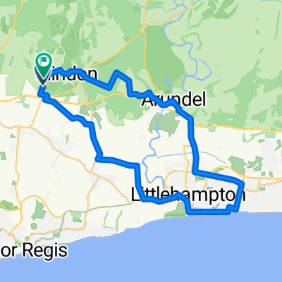
Charlton Climb - New barn Hill 22er Loop
A cycling route starting in Fontwell, England, United Kingdom.
Overview
About this route
<span style="font-family: Arial; color: #535353; font-size: 6pt;">
<span style="font-family: Arial; color: #535353; font-size: 8pt; mso-bidi-font-size: 6.0pt;">Start at car park. Fast ride down hill to Upwaltham, along </span><span style="font-family: Arial; color: #535353; font-size: 8pt; mso-bidi-font-size: 6.0pt;">Droke Lane</span><span style="font-family: Arial; color: #535353; font-size: 8pt; mso-bidi-font-size: 6.0pt;">, through East Dean to Charlton. Climb up Knights Hill to Trundle, good steep climb on narrow lane. Fast ride down Kennel Hill – hold on to your hat! Along </span><span style="font-family: Arial; color: #535353; font-size: 8pt; mso-bidi-font-size: 6.0pt;">New Road</span><span style="font-family: Arial; color: #535353; font-size: 8pt; mso-bidi-font-size: 6.0pt;">, then North up New Barn Hill. One of my favourite climbs. Starts at 27 metres 14k out and reaches 153m at junction. Turn right onto </span><span style="font-family: Arial; color: #535353; font-size: 8pt; mso-bidi-font-size: 6.0pt;">Selhurstpark Road</span><span style="font-family: Arial; color: #535353; font-size: 8pt; mso-bidi-font-size: 6.0pt;"> but don’t expect the climbing to stop. The Gradient continues until just under the 20k mark. Now at 179m. A 153m climb over 6k. <span style="mso-spacerun: yes;"> </span>Selhurstpark road eventually levels out for a nice finish back at the car park. <span style="mso-spacerun: yes;"> </span>A good leg burner with two good climbs!</span> </span>
- -:--
- Duration
- 21.7 km
- Distance
- 274 m
- Ascent
- 273 m
- Descent
- ---
- Avg. speed
- ---
- Max. altitude

Route quality
Waytypes & surfaces along the route
Waytypes
Road
18.3 km
(84 %)
Quiet road
2 km
(9 %)
Undefined
1.5 km
(7 %)
Surfaces
Paved
8.5 km
(39 %)
Asphalt
8.5 km
(39 %)
Undefined
13.3 km
(61 %)
Route highlights
Points of interest along the route
Point of interest after 0.1 km
Fast decent down A285 - good time to test your brakes!
Point of interest after 8.1 km
Climb starts here at Charlton 64m climbing to 160m - 96m of ascent on very narrow tack. Keep an eye out for cars coming down and use passing bays.
Point of interest after 10.3 km
Very fast decent
Point of interest after 13.9 km
Start of good climb
Point of interest after 17.6 km
At the top of New Barn Hill turn right into Selhurstpark Road but the climbing does not stop.
Continue with Bikemap
Use, edit, or download this cycling route
You would like to ride Charlton Climb - New barn Hill 22er Loop or customize it for your own trip? Here is what you can do with this Bikemap route:
Free features
- Save this route as favorite or in collections
- Copy & plan your own version of this route
- Sync your route with Garmin or Wahoo
Premium features
Free trial for 3 days, or one-time payment. More about Bikemap Premium.
- Navigate this route on iOS & Android
- Export a GPX / KML file of this route
- Create your custom printout (try it for free)
- Download this route for offline navigation
Discover more Premium features.
Get Bikemap PremiumFrom our community
Other popular routes starting in Fontwell
 Slindon Bottom Road, Arundel to Slindon Bottom Road, Arundel
- Distance
- 34.7 km
- Ascent
- 254 m
- Descent
- 254 m
- Location
- Fontwell, England, United Kingdom
 Charlton Climb - New barn Hill 22er Loop
- Distance
- 21.7 km
- Ascent
- 274 m
- Descent
- 273 m
- Location
- Fontwell, England, United Kingdom
 Slindon Woods Car Park 26er
- Distance
- 26 km
- Ascent
- 249 m
- Descent
- 249 m
- Location
- Fontwell, England, United Kingdom
 Slindon - Arundel - Bury - Bignor - Upwaltham - Eartham - Slindon Circuit
- Distance
- 55.9 km
- Ascent
- 861 m
- Descent
- 862 m
- Location
- Fontwell, England, United Kingdom
 Fontwell - Lewes
- Distance
- 54.4 km
- Ascent
- 839 m
- Descent
- 1,007 m
- Location
- Fontwell, England, United Kingdom
 short mtb
- Distance
- 29.9 km
- Ascent
- 566 m
- Descent
- 566 m
- Location
- Fontwell, England, United Kingdom
 Wiggle Fallen Leaves MTB
- Distance
- 50.8 km
- Ascent
- 707 m
- Descent
- 708 m
- Location
- Fontwell, England, United Kingdom
 1.hr Loop
- Distance
- 18.8 km
- Ascent
- 299 m
- Descent
- 300 m
- Location
- Fontwell, England, United Kingdom
Open it in the app