

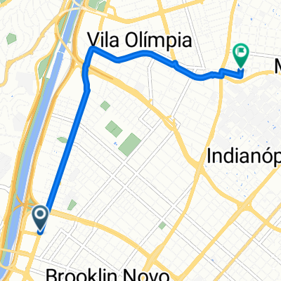
Portal-Do-Morumbi-Vila-Olimpia-pelo-caminho-mais-curto
A cycling route starting in Taboão da Serra, São Paulo, Brazil.
Overview
About this route
A more general route, but avoiding unpleasant stretches if that increases the journey a little.
- -:--
- Duration
- 10 km
- Distance
- 171 m
- Ascent
- 198 m
- Descent
- ---
- Avg. speed
- ---
- Max. altitude
Route highlights
Points of interest along the route
Point of interest after 0 km
Inicie empurrando a bicicleta na contra-mão por 50m.
Point of interest after 5.9 km
Travessia perigosa! Aqui temos que descer e atravessar a ponte empurrando a bicicleta no caminho dos pedestres.
Continue with Bikemap
Use, edit, or download this cycling route
You would like to ride Portal-Do-Morumbi-Vila-Olimpia-pelo-caminho-mais-curto or customize it for your own trip? Here is what you can do with this Bikemap route:
Free features
- Save this route as favorite or in collections
- Copy & plan your own version of this route
- Sync your route with Garmin or Wahoo
Premium features
Free trial for 3 days, or one-time payment. More about Bikemap Premium.
- Navigate this route on iOS & Android
- Export a GPX / KML file of this route
- Create your custom printout (try it for free)
- Download this route for offline navigation
Discover more Premium features.
Get Bikemap PremiumFrom our community
Other popular routes starting in Taboão da Serra
![BikeMap[comute]](https://media.bikemap.net/routes/17552678/staticmaps/in_be1791f0-97cd-4aa6-ace7-effad91838c9_400x400_bikemap-2021-3D-static.png) BikeMap[comute]
BikeMap[comute]- Distance
- 4.4 km
- Ascent
- 33 m
- Descent
- 92 m
- Location
- Taboão da Serra, São Paulo, Brazil
 De Rodovia Régis Bittencourt a Avenida Paulista
- Distance
- 25.3 km
- Ascent
- 551 m
- Descent
- 460 m
- Location
- Taboão da Serra, São Paulo, Brazil
 Rua : próspero Cesarino paoliello
- Distance
- 8.2 km
- Ascent
- 110 m
- Descent
- 93 m
- Location
- Taboão da Serra, São Paulo, Brazil
 Rota para Avenida Eliseu de Almeida
- Distance
- 22.9 km
- Ascent
- 1,473 m
- Descent
- 1,545 m
- Location
- Taboão da Serra, São Paulo, Brazil
 Portal-Do-Morumbi-Vila-Olimpia-quase-sem-subidas
- Distance
- 13.5 km
- Ascent
- 98 m
- Descent
- 145 m
- Location
- Taboão da Serra, São Paulo, Brazil
 Rota de quinta rápida com subidas
- Distance
- 44.8 km
- Ascent
- 256 m
- Descent
- 257 m
- Location
- Taboão da Serra, São Paulo, Brazil
 Route to Barbearia Nova
- Distance
- 5.1 km
- Ascent
- 34 m
- Descent
- 17 m
- Location
- Taboão da Serra, São Paulo, Brazil
 Rodovia Régis Bittencourt, Taboão da Serra a Rua Cachoeirinha, Taboão da Serra
- Distance
- 23.5 km
- Ascent
- 276 m
- Descent
- 251 m
- Location
- Taboão da Serra, São Paulo, Brazil
Open it in the app