

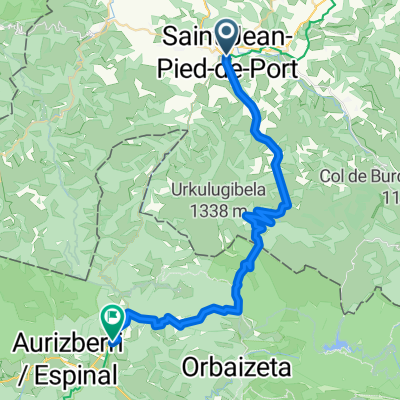
Camino de Santiago 1a tappa: St.Jean-Pied-de-Port - Roncisvalle
A cycling route starting in Saint-Jean-Pied-de-Port, Nouvelle-Aquitaine, France.
Overview
About this route
- Monday, August 9, 2004 - Stage 1: St. Jean-Pied de Port - Roncesvalles 27 km on the route (48 km and 1500 m climbed due to route error) Departure in rain and fog After collecting the pilgrim's 'Credencial', we departed around noon. Instead of taking the valley bottom road, recommended in bad weather, due to incorrect information, we took the high path of the route. When we realized the mistake, we were already too far along, and unable to continue, we turned back (on incorrect instruction from a refuge keeper) to an 'alternative' mountain route which brought us to Roncesvalles late in the evening, adding 21 km to the original route. We found lodging in a container and met Joserra, a Basque friend we would meet again later.
- -:--
- Duration
- 26.9 km
- Distance
- 1,071 m
- Ascent
- 279 m
- Descent
- ---
- Avg. speed
- ---
- Max. altitude

Route quality
Waytypes & surfaces along the route
Waytypes
Cycleway
16.9 km
(63 %)
Quiet road
2.1 km
(8 %)
Surfaces
Paved
2.1 km
(8 %)
Asphalt
2.1 km
(8 %)
Undefined
24.7 km
(92 %)
Continue with Bikemap
Use, edit, or download this cycling route
You would like to ride Camino de Santiago 1a tappa: St.Jean-Pied-de-Port - Roncisvalle or customize it for your own trip? Here is what you can do with this Bikemap route:
Free features
- Save this route as favorite or in collections
- Copy & plan your own version of this route
- Sync your route with Garmin or Wahoo
Premium features
Free trial for 3 days, or one-time payment. More about Bikemap Premium.
- Navigate this route on iOS & Android
- Export a GPX / KML file of this route
- Create your custom printout (try it for free)
- Download this route for offline navigation
Discover more Premium features.
Get Bikemap PremiumFrom our community
Other popular routes starting in Saint-Jean-Pied-de-Port
 2012 T2
- Distance
- 116.4 km
- Ascent
- 1,580 m
- Descent
- 1,225 m
- Location
- Saint-Jean-Pied-de-Port, Nouvelle-Aquitaine, France
 Saint-Jean-Pied-de-Port - Estella-Lizarra
- Distance
- 164 km
- Ascent
- 4,255 m
- Descent
- 3,977 m
- Location
- Saint-Jean-Pied-de-Port, Nouvelle-Aquitaine, France
 Camino de Santiago 2009
- Distance
- 811.8 km
- Ascent
- 4,314 m
- Descent
- 4,212 m
- Location
- Saint-Jean-Pied-de-Port, Nouvelle-Aquitaine, France
 St Jean Pied de Port, France to Burguete, Spain
- Distance
- 39.9 km
- Ascent
- 1,727 m
- Descent
- 998 m
- Location
- Saint-Jean-Pied-de-Port, Nouvelle-Aquitaine, France
 (ES) Camino Frances (Saint-Jean-Pied-de-Port - Santiago de Compostela)
- Distance
- 993.8 km
- Ascent
- 17,961 m
- Descent
- 17,906 m
- Location
- Saint-Jean-Pied-de-Port, Nouvelle-Aquitaine, France
 Spanien EuroVelo 3
- Distance
- 940.5 km
- Ascent
- 17,417 m
- Descent
- 17,553 m
- Location
- Saint-Jean-Pied-de-Port, Nouvelle-Aquitaine, France
 Tracé 028 001 001
- Distance
- 42.8 km
- Ascent
- 2,502 m
- Descent
- 1,794 m
- Location
- Saint-Jean-Pied-de-Port, Nouvelle-Aquitaine, France
 Saint-Jean-Pied-de-Port - Louvie-Juzon
- Distance
- 104.9 km
- Ascent
- 2,640 m
- Descent
- 2,313 m
- Location
- Saint-Jean-Pied-de-Port, Nouvelle-Aquitaine, France
Open it in the app