
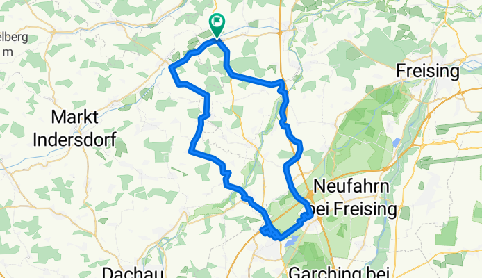
Hohenkammer - Unterschleissheim
A cycling route starting in Hohenkammer, Bavaria, Germany.
Overview
About this route
- -:--
- Duration
- 51.9 km
- Distance
- 283 m
- Ascent
- 268 m
- Descent
- ---
- Avg. speed
- 503 m
- Max. altitude

Route quality
Waytypes & surfaces along the route
Waytypes
Quiet road
18.6 km
(36 %)
Road
17.4 km
(34 %)
Surfaces
Paved
41 km
(79 %)
Unpaved
0.1 km
(<1 %)
Asphalt
40.8 km
(79 %)
Paving stones
0.1 km
(<1 %)
Continue with Bikemap
Use, edit, or download this cycling route
You would like to ride Hohenkammer - Unterschleissheim or customize it for your own trip? Here is what you can do with this Bikemap route:
Free features
- Save this route as favorite or in collections
- Copy & plan your own version of this route
- Sync your route with Garmin or Wahoo
Premium features
Free trial for 3 days, or one-time payment. More about Bikemap Premium.
- Navigate this route on iOS & Android
- Export a GPX / KML file of this route
- Create your custom printout (try it for free)
- Download this route for offline navigation
Discover more Premium features.
Get Bikemap PremiumFrom our community
Other popular routes starting in Hohenkammer
 Schlipps - Allershausen- Kranzberg - Schlipps
- Distance
- 24.6 km
- Ascent
- 36 m
- Descent
- 24 m
- Location
- Hohenkammer, Bavaria, Germany
 Straßentour Markt Indersdorf
- Distance
- 39.8 km
- Ascent
- 113 m
- Descent
- 111 m
- Location
- Hohenkammer, Bavaria, Germany
 Hohenkammer - Unterschleissheim
- Distance
- 51.9 km
- Ascent
- 283 m
- Descent
- 268 m
- Location
- Hohenkammer, Bavaria, Germany
 Moni Reichertshausen Wippenhausen
- Distance
- 47.7 km
- Ascent
- 336 m
- Descent
- 335 m
- Location
- Hohenkammer, Bavaria, Germany
 Schlipps - Edeka Allershausen
- Distance
- 8.6 km
- Ascent
- 335 m
- Descent
- 43 m
- Location
- Hohenkammer, Bavaria, Germany
 Wasserburg - Wasserburg 02
- Distance
- 94.9 km
- Ascent
- 306 m
- Descent
- 363 m
- Location
- Hohenkammer, Bavaria, Germany
 Hohenkammer Bierhütte
- Distance
- 204.4 km
- Ascent
- 805 m
- Descent
- 596 m
- Location
- Hohenkammer, Bavaria, Germany
 Altbaierischer Oxenweg im Dachauer Land
- Distance
- 40.4 km
- Ascent
- 143 m
- Descent
- 86 m
- Location
- Hohenkammer, Bavaria, Germany
Open it in the app