

Dookoła Polski 7 dzień (Zawoja- Louky)
A cycling route starting in Zawoja, Lesser Poland Voivodeship, Poland.
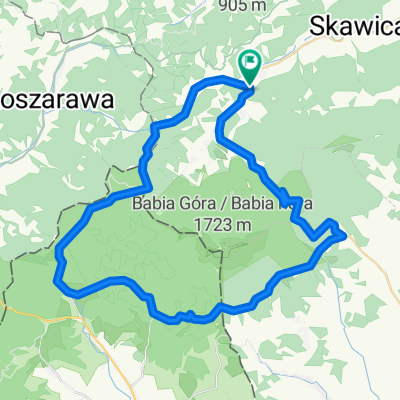
Overview
About this route
7th day Sunday 10.07.2011
Distance 134.4 km Time 7:09 hours Avg speed 18.78 km/h Max speed 67.97 km/h !!!
In the morning, after breakfast, I drove the girls (this time by car;) to Mosorny Groń. After a short chat with the hostess, I head on my way. The beginning of the route is well known to me from my winter ski trips. So I ride on without unnecessary stops to check the map. A serious climb up to Przysłup and then a descent to Stryszawy, Lachowice and direction Żywiec. I wanted to skip this town, but I couldn’t and I got lost. Finally, with the help of locals, I found the exit to Zwardoń. After a few kilometers, there’s a sign …
no entry for bicycles, tractors, and carts, but I keep going because there’s really nowhere to turn off. The heat, climbs, soundproofing walls, and heavy traffic made me feel as if I were in a microwave after a while. After reaching Węgierska Górka, I escape from the two-lane road. I cool my overheated legs in a stream – a tributary of the Soła. Then along the bank of the river to Milówka, where a historical reconstruction of World War II took place. After watching a fragment, I ride towards Koniaków. I meet again a road sign I am familiar with. I search the map for a detour through the village of Szare. Initially quiet, picturesque, a resident tells me something about an ascent. I say that I’ll manage, thinking of the climb I know to Koniaków. It turns out that at the end of the village there’s a climb that defeated me. The concrete slabs and the angle of incline did not allow me to ride, I had to push all my belongings, with considerable effort too. Another “best”
Later the previously mentioned climb to Koniaków. It wasn’t easy either under the blazing sun. As a reward, a break for pizza and a small cola (0.25l – 2.5 zł!). Descent towards the Jasnowice border crossing. Just after the border, a cold beer 1% Budweiser (0.5l – 1.7 zł!) – yum. I’m heading towards Jablunkova, again a 12% climb, but luckily short. Then heading towards Trinca, along the way a break for knedliky (much better than pizza). The roads are signposted remarkably, I don’t even have to glance at the map. That probably lulled my vigilance, in Český Těšín, a sign points towards “Katowice”. I’m going but the traffic is getting heavier and there’s no exit. More guided by the setting sun than by the map, I find a way towards Karvina. It’s time to look for a place to stay overnight but I didn’t buy anything to eat because I thought I would reach Poland before dusk. On the right side of the road, I notice a sign that says "Pozor hranice" and an exit from the road. There’s a dream spot to camp, by the Olza. On the other side of the river, it’s already Poland. However, I don’t risk crossing the rushing currents. At the water step, a group of youth from Poland and a Czech family are splashing around. A friendly bearded Czech Rumcajs says I can safely set up camp. It’s probably illegal, but nobody will chop my head off for it, and to think that just a dozen years earlier something like this would have been completely impossible. "This world is strange" He also advises me to go the next day to Karvina and the crossing at Godów. After setting up the tent, I enjoy the "river jacuzzi", something fantastic. The water falling from the water step created a small waterfall that wonderfully massaged my tired back and legs. After the bath, a very exquisite meal. I enjoy a packet of "żurek with croutons" paired (small portion) with "mushroom soup with crispy croutons". I munch on all this with bread (from Friday) from Ewa, brought from Łódź (Jagodnica). Not a bad set ;) ! I look wistfully at the "Harnasia" (just 1 also from Ewa) cooling in the water and I’m afraid the river current might sweep it away. A beer like this at home, but here and now what flavor, poetry. Before sleeping, another repeat of the hydromassage.
- -:--
- Duration
- 124.5 km
- Distance
- 827 m
- Ascent
- 1,152 m
- Descent
- ---
- Avg. speed
- ---
- Max. altitude

Route highlights
Points of interest along the route
\"")
Photo after 7.5 km
Przełęcz Przysłop
\"")
Photo after 58.6 km
Panorama Węgierskiej Górki.
\"")
Point of interest after 64.5 km
historyczna rekonstrukcja w Milówce
\"")
Photo after 70.7 km
Podjazd, który mnie "pokonał"
\"")
Point of interest after 71.9 km
Przed konkretnym podjazdem. Tym razem do Koniakowa.
\"")
Accommodation after 124.5 km
Widok z mojego *****hotelu na Olzę
Continue with Bikemap
Use, edit, or download this cycling route
You would like to ride Dookoła Polski 7 dzień (Zawoja- Louky) or customize it for your own trip? Here is what you can do with this Bikemap route:
Free features
- Save this route as favorite or in collections
- Copy & plan your own version of this route
- Split it into stages to create a multi-day tour
- Sync your route with Garmin or Wahoo
Premium features
Free trial for 3 days, or one-time payment. More about Bikemap Premium.
- Navigate this route on iOS & Android
- Export a GPX / KML file of this route
- Create your custom printout (try it for free)
- Download this route for offline navigation
Discover more Premium features.
Get Bikemap PremiumFrom our community
Other popular routes starting in Zawoja
 zawoja2
- Distance
- 14.9 km
- Ascent
- 509 m
- Descent
- 511 m
- Location
- Zawoja, Lesser Poland Voivodeship, Poland
 Dookoła Polski 7 dzień (Zawoja- Louky)
- Distance
- 124.5 km
- Ascent
- 827 m
- Descent
- 1,152 m
- Location
- Zawoja, Lesser Poland Voivodeship, Poland
 Zawoja
- Distance
- 59.9 km
- Ascent
- 813 m
- Descent
- 834 m
- Location
- Zawoja, Lesser Poland Voivodeship, Poland
 Wokół Babiej Góry
- Distance
- 50 km
- Ascent
- 1,057 m
- Descent
- 1,055 m
- Location
- Zawoja, Lesser Poland Voivodeship, Poland
 Zawoja do Zawoja
- Distance
- 36.6 km
- Ascent
- 2,009 m
- Descent
- 2,003 m
- Location
- Zawoja, Lesser Poland Voivodeship, Poland
 Wokół Babiej Góry
- Distance
- 54.3 km
- Ascent
- 1,099 m
- Descent
- 1,099 m
- Location
- Zawoja, Lesser Poland Voivodeship, Poland
 Zawoja Zawoja (Giro Babia classic)
- Distance
- 123.5 km
- Ascent
- 1,610 m
- Descent
- 1,604 m
- Location
- Zawoja, Lesser Poland Voivodeship, Poland
 Dookoła Babiej Góry
- Distance
- 46.4 km
- Ascent
- 1,274 m
- Descent
- 1,274 m
- Location
- Zawoja, Lesser Poland Voivodeship, Poland
Open it in the app