
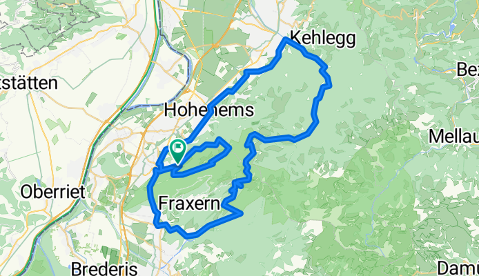
Trainingsstrecke
A cycling route starting in Altach, Vorarlberg, Austria.
Overview
About this route
Götzis Berg - Weiler - Viktorsberg - Hohe Kugel - Emser Hütte - Pfarrers Älpele - Ebnit - Dornbirn Gütle - Götzis Berg - Millrütte - Alpe Gsohl - Götzis Berg
- -:--
- Duration
- 55.7 km
- Distance
- 1,892 m
- Ascent
- 1,892 m
- Descent
- ---
- Avg. speed
- ---
- Max. altitude

Continue with Bikemap
Use, edit, or download this cycling route
You would like to ride Trainingsstrecke or customize it for your own trip? Here is what you can do with this Bikemap route:
Free features
- Save this route as favorite or in collections
- Copy & plan your own version of this route
- Sync your route with Garmin or Wahoo
Premium features
Free trial for 3 days, or one-time payment. More about Bikemap Premium.
- Navigate this route on iOS & Android
- Export a GPX / KML file of this route
- Create your custom printout (try it for free)
- Download this route for offline navigation
Discover more Premium features.
Get Bikemap PremiumFrom our community
Other popular routes starting in Altach
 Dornbirner Höhenweg - Buch 60 km - 650hm
- Distance
- 58.9 km
- Ascent
- 466 m
- Descent
- 468 m
- Location
- Altach, Vorarlberg, Austria
 Altach - Gsohl
- Distance
- 17.9 km
- Ascent
- 572 m
- Descent
- 575 m
- Location
- Altach, Vorarlberg, Austria
 Big One 100
- Distance
- 131.3 km
- Ascent
- 3,110 m
- Descent
- 3,111 m
- Location
- Altach, Vorarlberg, Austria
 Altach-Zollikerberg
- Distance
- 140.8 km
- Ascent
- 1,569 m
- Descent
- 1,395 m
- Location
- Altach, Vorarlberg, Austria
 Götzis - Gapfohl - Alpweg Kopf - Dafins - Masella - Röthis - Viktorsberg - Letze - Orsanka - Maisaß - Schwimmersboden - Lugtrail
- Distance
- 70.2 km
- Ascent
- 2,714 m
- Descent
- 2,713 m
- Location
- Altach, Vorarlberg, Austria
 4th Big One
- Distance
- 88.3 km
- Ascent
- 2,791 m
- Descent
- 2,790 m
- Location
- Altach, Vorarlberg, Austria
 Götzis - Hoher Kasten - Hohe Kugel - Götzis
- Distance
- 86.3 km
- Ascent
- 2,561 m
- Descent
- 2,561 m
- Location
- Altach, Vorarlberg, Austria
 Berkmannweg to Sandholzerstraße
- Distance
- 19.3 km
- Ascent
- 49 m
- Descent
- 100 m
- Location
- Altach, Vorarlberg, Austria
Open it in the app