

hoi
A cycling route starting in Bar-sur-Aube, Grand Est, France.
Overview
About this route
- -:--
- Duration
- 166.4 km
- Distance
- 232 m
- Ascent
- 378 m
- Descent
- ---
- Avg. speed
- ---
- Max. altitude
Route quality
Waytypes & surfaces along the route
Waytypes
Track
41.6 km
(25 %)
Quiet road
15 km
(9 %)
Surfaces
Paved
61.6 km
(37 %)
Unpaved
1.7 km
(1 %)
Asphalt
59.9 km
(36 %)
Paved (undefined)
1.7 km
(1 %)
Continue with Bikemap
Use, edit, or download this cycling route
You would like to ride hoi or customize it for your own trip? Here is what you can do with this Bikemap route:
Free features
- Save this route as favorite or in collections
- Copy & plan your own version of this route
- Split it into stages to create a multi-day tour
- Sync your route with Garmin or Wahoo
Premium features
Free trial for 3 days, or one-time payment. More about Bikemap Premium.
- Navigate this route on iOS & Android
- Export a GPX / KML file of this route
- Create your custom printout (try it for free)
- Download this route for offline navigation
Discover more Premium features.
Get Bikemap PremiumFrom our community
Other popular routes starting in Bar-sur-Aube
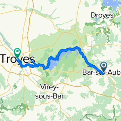 troyes
- Distance
- 72.1 km
- Ascent
- 436 m
- Descent
- 492 m
- Location
- Bar-sur-Aube, Grand Est, France
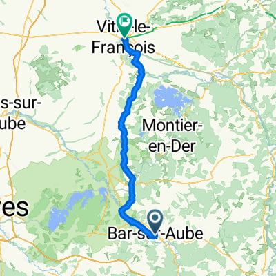 Rue Nationale, Bar-sur-Aube to Rue Domyné de Verzet, Vitry-le-François
- Distance
- 73.6 km
- Ascent
- 469 m
- Descent
- 535 m
- Location
- Bar-sur-Aube, Grand Est, France
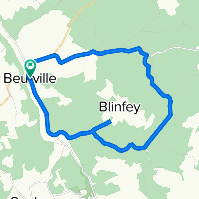 2 Rue des Crêts, Beurville à 2 Rue des Crêts, Beurville
- Distance
- 17.4 km
- Ascent
- 233 m
- Descent
- 231 m
- Location
- Bar-sur-Aube, Grand Est, France
 Recovered Route
- Distance
- 10.6 km
- Ascent
- 71 m
- Descent
- 77 m
- Location
- Bar-sur-Aube, Grand Est, France
 VF_2011_06_BarSurAube_Champlitte
- Distance
- 111.6 km
- Ascent
- 647 m
- Descent
- 569 m
- Location
- Bar-sur-Aube, Grand Est, France
 fr21-bar sur aube_chateauvillain
- Distance
- 33.5 km
- Ascent
- 400 m
- Descent
- 335 m
- Location
- Bar-sur-Aube, Grand Est, France
 Champagne Etape 7
- Distance
- 63.8 km
- Ascent
- 111 m
- Descent
- 141 m
- Location
- Bar-sur-Aube, Grand Est, France
 FR3P 2-2 Sonntag Nachmittag: Bar-sur-Aube - Romily-sur-Seine
- Distance
- 108.9 km
- Ascent
- 282 m
- Descent
- 379 m
- Location
- Bar-sur-Aube, Grand Est, France
Open it in the app