Custom Route - Sheldon 9/12/23
A cycling route starting in Omaha, Nebraska, United States.
Overview
About this route
- -:--
- Duration
- 39.1 km
- Distance
- 341 m
- Ascent
- 340 m
- Descent
- ---
- Avg. speed
- 381 m
- Max. altitude
Route quality
Waytypes & surfaces along the route
Waytypes
Cycleway
17.8 km
(46 %)
Road
13.4 km
(34 %)
Surfaces
Paved
34.2 km
(87 %)
Unpaved
0.3 km
(<1 %)
Concrete
15.9 km
(41 %)
Asphalt
8.8 km
(22 %)
Route highlights
Points of interest along the route
Point of interest after 11.8 km
Lewis and Clark Memorial Park
Point of interest after 25.3 km
Closed Trail Center
Point of interest after 30.8 km
Veterans Memorial Bridge
Point of interest after 33.6 km
Infield at the Zoo, Rosenblatt
Point of interest after 33.9 km
Henry Doorly
Point of interest after 37.5 km
Chef Boyardee
Point of interest after 38.2 km
Omaha's Old Market
Continue with Bikemap
Use, edit, or download this cycling route
You would like to ride Custom Route - Sheldon 9/12/23 or customize it for your own trip? Here is what you can do with this Bikemap route:
Free features
- Save this route as favorite or in collections
- Copy & plan your own version of this route
- Sync your route with Garmin or Wahoo
Premium features
Free trial for 3 days, or one-time payment. More about Bikemap Premium.
- Navigate this route on iOS & Android
- Export a GPX / KML file of this route
- Create your custom printout (try it for free)
- Download this route for offline navigation
Discover more Premium features.
Get Bikemap PremiumFrom our community
Other popular routes starting in Omaha
- Two Bridge Tour
- Distance
- 22.9 km
- Ascent
- 226 m
- Descent
- 227 m
- Location
- Omaha, Nebraska, United States
- ride through Omaha
- Distance
- 12.5 km
- Ascent
- 140 m
- Descent
- 142 m
- Location
- Omaha, Nebraska, United States
- Omaha to Council Bluffs
- Distance
- 27.9 km
- Ascent
- 93 m
- Descent
- 95 m
- Location
- Omaha, Nebraska, United States
- michaels crafts route there
- Distance
- 18.3 km
- Ascent
- 167 m
- Descent
- 171 m
- Location
- Omaha, Nebraska, United States
- Custom Route - Sheldon 9/12/23
- Distance
- 39.1 km
- Ascent
- 341 m
- Descent
- 340 m
- Location
- Omaha, Nebraska, United States
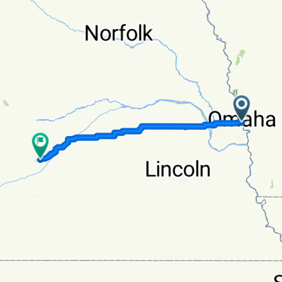
- Burt St, Omaha to Lake Cunningham Trail, Omaha
- Distance
- 17.7 km
- Ascent
- 81 m
- Descent
- 103 m
- Location
- Omaha, Nebraska, United States
- Council Bluffs Levee Road to Council Bluffs Levee Road
- Distance
- 6.6 km
- Ascent
- 353 m
- Descent
- 355 m
- Location
- Omaha, Nebraska, United States
- Bob the Bridge to Lake
- Distance
- 26.1 km
- Ascent
- 97 m
- Descent
- 72 m
- Location
- Omaha, Nebraska, United States
Open it in the app