

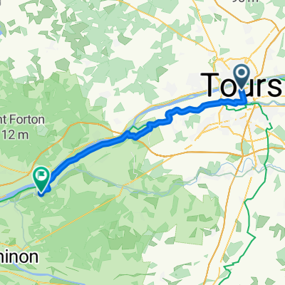
La Loire à Vélo avec guide
A cycling route starting in Tours, Centre-Val de Loire, France.
Overview
About this route
Easy course, generally on bike paths and quiet roads along the Loire.
- -:--
- Duration
- 75.4 km
- Distance
- 215 m
- Ascent
- 233 m
- Descent
- ---
- Avg. speed
- ---
- Max. altitude

Route quality
Waytypes & surfaces along the route
Waytypes
Road
28.6 km
(38 %)
Quiet road
11.3 km
(15 %)
Surfaces
Paved
53.5 km
(71 %)
Asphalt
53.5 km
(71 %)
Undefined
21.9 km
(29 %)
Route highlights
Points of interest along the route
Point of interest after 0.8 km
Point of interest after 5.5 km
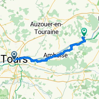
Point of interest after 22.4 km
Villandry
Point of interest after 39.1 km
Azay-le-Rideau
Point of interest after 50.3 km
Bréhémont
Point of interest after 75.2 km
Chinon
Continue with Bikemap
Use, edit, or download this cycling route
You would like to ride La Loire à Vélo avec guide or customize it for your own trip? Here is what you can do with this Bikemap route:
Free features
- Save this route as favorite or in collections
- Copy & plan your own version of this route
- Sync your route with Garmin or Wahoo
Premium features
Free trial for 3 days, or one-time payment. More about Bikemap Premium.
- Navigate this route on iOS & Android
- Export a GPX / KML file of this route
- Create your custom printout (try it for free)
- Download this route for offline navigation
Discover more Premium features.
Get Bikemap PremiumFrom our community
Other popular routes starting in Tours
 La Loire à Vélo avec guide
- Distance
- 75.4 km
- Ascent
- 215 m
- Descent
- 233 m
- Location
- Tours, Centre-Val de Loire, France
 Tours Hommes Azay 100k
- Distance
- 95.4 km
- Ascent
- 569 m
- Descent
- 567 m
- Location
- Tours, Centre-Val de Loire, France
 Tour 4: Tours bis Amboise
- Distance
- 29.8 km
- Ascent
- 141 m
- Descent
- 120 m
- Location
- Tours, Centre-Val de Loire, France
 Part 2
- Distance
- 282.9 km
- Ascent
- 69 m
- Descent
- 120 m
- Location
- Tours, Centre-Val de Loire, France
 Day 4, Tours to Rigny-Ussé
- Distance
- 40.5 km
- Ascent
- 132 m
- Descent
- 134 m
- Location
- Tours, Centre-Val de Loire, France
 Tours to Veuzain-Sur-Loire
- Distance
- 55.3 km
- Ascent
- 311 m
- Descent
- 299 m
- Location
- Tours, Centre-Val de Loire, France
 Loire Bike Tour
- Distance
- 200.6 km
- Ascent
- 1,311 m
- Descent
- 1,319 m
- Location
- Tours, Centre-Val de Loire, France
 Tours boucle 25 km
- Distance
- 27 km
- Ascent
- 15 m
- Descent
- 14 m
- Location
- Tours, Centre-Val de Loire, France
Open it in the app