

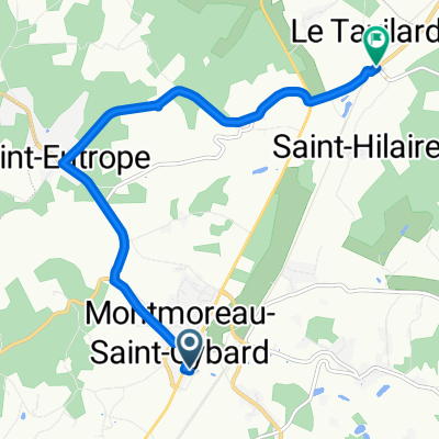
naar berneuil conzac blanzac en st-eutrope
A cycling route starting in Montmoreau-Saint-Cybard, Nouvelle-Aquitaine, France.
Overview
About this route
- -:--
- Duration
- 52.6 km
- Distance
- 725 m
- Ascent
- 725 m
- Descent
- ---
- Avg. speed
- 184 m
- Max. altitude
Route quality
Waytypes & surfaces along the route
Waytypes
Road
27.8 km
(53 %)
Quiet road
17.7 km
(34 %)
Route highlights
Points of interest along the route
Point of interest after 31.2 km
chapelle des templiers
Continue with Bikemap
Use, edit, or download this cycling route
You would like to ride naar berneuil conzac blanzac en st-eutrope or customize it for your own trip? Here is what you can do with this Bikemap route:
Free features
- Save this route as favorite or in collections
- Copy & plan your own version of this route
- Sync your route with Garmin or Wahoo
Premium features
Free trial for 3 days, or one-time payment. More about Bikemap Premium.
- Navigate this route on iOS & Android
- Export a GPX / KML file of this route
- Create your custom printout (try it for free)
- Download this route for offline navigation
Discover more Premium features.
Get Bikemap PremiumFrom our community
Other popular routes starting in Montmoreau-Saint-Cybard
 aubeterre st-severin palluaud juignac
- Distance
- 49.4 km
- Ascent
- 596 m
- Descent
- 595 m
- Location
- Montmoreau-Saint-Cybard, Nouvelle-Aquitaine, France
 bellon saint-severin
- Distance
- 42.3 km
- Ascent
- 518 m
- Descent
- 517 m
- Location
- Montmoreau-Saint-Cybard, Nouvelle-Aquitaine, France
 Europe Day92
- Distance
- 58.5 km
- Ascent
- 149 m
- Descent
- 279 m
- Location
- Montmoreau-Saint-Cybard, Nouvelle-Aquitaine, France
 naar Aubeterre en Saint-severin
- Distance
- 45.7 km
- Ascent
- 613 m
- Descent
- 610 m
- Location
- Montmoreau-Saint-Cybard, Nouvelle-Aquitaine, France
 naar berneuil conzac blanzac en st-eutrope
- Distance
- 52.6 km
- Ascent
- 725 m
- Descent
- 725 m
- Location
- Montmoreau-Saint-Cybard, Nouvelle-Aquitaine, France
 Fictif E1
- Distance
- 7.8 km
- Ascent
- 108 m
- Descent
- 102 m
- Location
- Montmoreau-Saint-Cybard, Nouvelle-Aquitaine, France
 saint-laurent montboyer aubeterre
- Distance
- 38.1 km
- Ascent
- 574 m
- Descent
- 572 m
- Location
- Montmoreau-Saint-Cybard, Nouvelle-Aquitaine, France
 244 Impasse Chez Triboire, Courgeac naar 244 Impasse Chez Triboire, Courgeac
- Distance
- 45.5 km
- Ascent
- 681 m
- Descent
- 680 m
- Location
- Montmoreau-Saint-Cybard, Nouvelle-Aquitaine, France
Open it in the app