

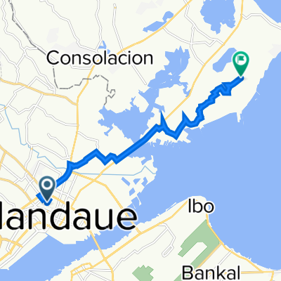
Lapu-Lapu Loop
A cycling route starting in Buagsong, Central Visayas, Philippines.
Overview
About this route
- -:--
- Duration
- 55.8 km
- Distance
- 60 m
- Ascent
- 61 m
- Descent
- ---
- Avg. speed
- 14 m
- Max. altitude

Route quality
Waytypes & surfaces along the route
Waytypes
Busy road
33.3 km
(60 %)
Road
9.3 km
(17 %)
Surfaces
Paved
31.4 km
(56 %)
Unpaved
0.3 km
(<1 %)
Concrete
21.3 km
(38 %)
Asphalt
9.5 km
(17 %)
Continue with Bikemap
Use, edit, or download this cycling route
You would like to ride Lapu-Lapu Loop or customize it for your own trip? Here is what you can do with this Bikemap route:
Free features
- Save this route as favorite or in collections
- Copy & plan your own version of this route
- Sync your route with Garmin or Wahoo
Premium features
Free trial for 3 days, or one-time payment. More about Bikemap Premium.
- Navigate this route on iOS & Android
- Export a GPX / KML file of this route
- Create your custom printout (try it for free)
- Download this route for offline navigation
Discover more Premium features.
Get Bikemap PremiumFrom our community
Other popular routes starting in Buagsong
 Mandaue City to Unnamed Road, Cebu City
- Distance
- 8.7 km
- Ascent
- 113 m
- Descent
- 86 m
- Location
- Buagsong, Central Visayas, Philippines
 M.L. Quezon National Highway, Lapu-Lapu City to Babag Night High School, Lapu-Lapu City
- Distance
- 5.9 km
- Ascent
- 154 m
- Descent
- 161 m
- Location
- Buagsong, Central Visayas, Philippines
 Lander
- Distance
- 55.2 km
- Ascent
- 237 m
- Descent
- 223 m
- Location
- Buagsong, Central Visayas, Philippines
 lapu2x
- Distance
- 18.2 km
- Ascent
- 555 m
- Descent
- 553 m
- Location
- Buagsong, Central Visayas, Philippines
 apolloview
- Distance
- 11 km
- Ascent
- 100 m
- Descent
- 73 m
- Location
- Buagsong, Central Visayas, Philippines
 Night ride
- Distance
- 16.6 km
- Ascent
- 95 m
- Descent
- 92 m
- Location
- Buagsong, Central Visayas, Philippines
 cebu mini loop 200 km
- Distance
- 215.8 km
- Ascent
- 785 m
- Descent
- 785 m
- Location
- Buagsong, Central Visayas, Philippines
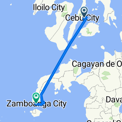 Cebu Zamboanga
- Distance
- 499.4 km
- Ascent
- 403 m
- Descent
- 400 m
- Location
- Buagsong, Central Visayas, Philippines
Open it in the app