

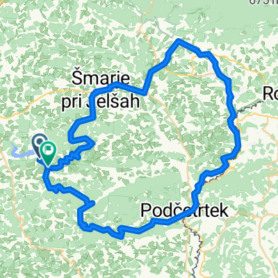
Kozjansko - Turistična (A)
A cycling route starting in Šentjur pri Celju, Šentjur Municipality, Slovenia.
Overview
About this route
Gorica pri SLivnici - Loka pri Žusmu - Podčetrtek - Olimje - Virštajn - Gubno - Krivica - Prevorje - Žegar - Gorica pri Slivnici
- -:--
- Duration
- 50 km
- Distance
- 925 m
- Ascent
- 924 m
- Descent
- ---
- Avg. speed
- 564 m
- Max. altitude
Route quality
Waytypes & surfaces along the route
Waytypes
Road
27.5 km
(55 %)
Quiet road
6.5 km
(13 %)
Surfaces
Paved
0.5 km
(1 %)
Asphalt
0.5 km
(1 %)
Undefined
49.5 km
(99 %)
Continue with Bikemap
Use, edit, or download this cycling route
You would like to ride Kozjansko - Turistična (A) or customize it for your own trip? Here is what you can do with this Bikemap route:
Free features
- Save this route as favorite or in collections
- Copy & plan your own version of this route
- Sync your route with Garmin or Wahoo
Premium features
Free trial for 3 days, or one-time payment. More about Bikemap Premium.
- Navigate this route on iOS & Android
- Export a GPX / KML file of this route
- Create your custom printout (try it for free)
- Download this route for offline navigation
Discover more Premium features.
Get Bikemap PremiumFrom our community
Other popular routes starting in Šentjur pri Celju
 Okrog Slivniškega jezera s štartom in ciljem v Šentjurju pri OŠ FM
- Distance
- 18.2 km
- Ascent
- 220 m
- Descent
- 223 m
- Location
- Šentjur pri Celju, Šentjur Municipality, Slovenia
 Šentjur - Celjska koča čez Svetino, povratek čez brda nad Štorami
- Distance
- 45.3 km
- Ascent
- 811 m
- Descent
- 811 m
- Location
- Šentjur pri Celju, Šentjur Municipality, Slovenia
 Sotensko pod Kalobjem 3 nach Rifnik und zurück
- Distance
- 9.9 km
- Ascent
- 356 m
- Descent
- 357 m
- Location
- Šentjur pri Celju, Šentjur Municipality, Slovenia
 Šentjur-šentrupert-laško-svetina-šentjur
- Distance
- 41.9 km
- Ascent
- 885 m
- Descent
- 885 m
- Location
- Šentjur pri Celju, Šentjur Municipality, Slovenia
 26: Planinski dom na Resevni – Planinski dom na Boču
- Distance
- 45.2 km
- Ascent
- 1,076 m
- Descent
- 1,051 m
- Location
- Šentjur pri Celju, Šentjur Municipality, Slovenia
 Kozjansko - Panoramska (B)
- Distance
- 45.1 km
- Ascent
- 1,083 m
- Descent
- 1,082 m
- Location
- Šentjur pri Celju, Šentjur Municipality, Slovenia
 Kozjanska 4
- Distance
- 59.2 km
- Ascent
- 559 m
- Descent
- 550 m
- Location
- Šentjur pri Celju, Šentjur Municipality, Slovenia
 Gregor 11
- Distance
- 16.5 km
- Ascent
- 585 m
- Descent
- 591 m
- Location
- Šentjur pri Celju, Šentjur Municipality, Slovenia
Open it in the app