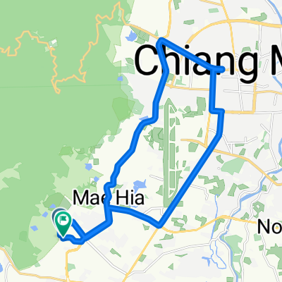
Nice short ride
A cycling route starting in Hang Dong, Chiang Mai Province, Thailand.
Overview
About this route
This little 12.2 mile (19.7km) loop has some nice climbs and some nice downhills paved and unpaved. I like to ride up Doi Kham... this can be skipped to make the it about a 10 mile (16km) loop.
- -:--
- Duration
- 19.7 km
- Distance
- 265 m
- Ascent
- 265 m
- Descent
- ---
- Avg. speed
- ---
- Avg. speed
Route quality
Waytypes & surfaces along the route
Waytypes
Quiet road
10.6 km
(54 %)
Busy road
6.1 km
(31 %)
Surfaces
Paved
18.4 km
(93 %)
Asphalt
16 km
(81 %)
Concrete
2.3 km
(12 %)
Undefined
1.3 km
(7 %)
Continue with Bikemap
Use, edit, or download this cycling route
You would like to ride Nice short ride or customize it for your own trip? Here is what you can do with this Bikemap route:
Free features
- Save this route as favorite or in collections
- Copy & plan your own version of this route
- Sync your route with Garmin or Wahoo
Premium features
Free trial for 3 days, or one-time payment. More about Bikemap Premium.
- Navigate this route on iOS & Android
- Export a GPX / KML file of this route
- Create your custom printout (try it for free)
- Download this route for offline navigation
Discover more Premium features.
Get Bikemap PremiumFrom our community
Other popular routes starting in Hang Dong
- to royal train via samoeng road
- Distance
- 10.6 km
- Ascent
- 112 m
- Descent
- 61 m
- Location
- Hang Dong, Chiang Mai Province, Thailand
- great for sunset!
- Distance
- 15.1 km
- Ascent
- 191 m
- Descent
- 192 m
- Location
- Hang Dong, Chiang Mai Province, Thailand
- Tambon Nam Phrae naar Tambon Nam Phrae
- Distance
- 16 km
- Ascent
- 188 m
- Descent
- 179 m
- Location
- Hang Dong, Chiang Mai Province, Thailand
- 77/232 Muban Kunlaphan Ville (Beaufort 1) Rd., Hang Dong to Soi Muban Kunlaphan Ville (Beaufort 3) Soi 4, Hang Dong
- Distance
- 28.3 km
- Ascent
- 69 m
- Descent
- 64 m
- Location
- Hang Dong, Chiang Mai Province, Thailand
- beautiful mountainous bike with one steep hill
- Distance
- 13 km
- Ascent
- 125 m
- Descent
- 124 m
- Location
- Hang Dong, Chiang Mai Province, Thailand
- Pimg river and new highway return
- Distance
- 68.6 km
- Ascent
- 38 m
- Descent
- 39 m
- Location
- Hang Dong, Chiang Mai Province, Thailand
- Outer Loop
- Distance
- 53.1 km
- Ascent
- 49 m
- Descent
- 51 m
- Location
- Hang Dong, Chiang Mai Province, Thailand
- Hang Dong Coffee Ride
- Distance
- 61.2 km
- Ascent
- 46 m
- Descent
- 49 m
- Location
- Hang Dong, Chiang Mai Province, Thailand