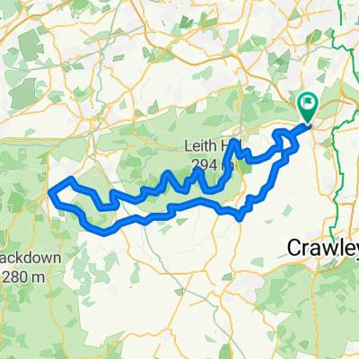
Reigate to Andover: RouteFinder 1
A cycling route starting in Reigate, England, United Kingdom.
Overview
About this route
Routefinder 1 to Milford. First half pretty flat and direct with several options to head north and return via Leith Hill.
- -:--
- Duration
- 101.1 km
- Distance
- 592 m
- Ascent
- 592 m
- Descent
- ---
- Avg. speed
- ---
- Avg. speed
Route quality
Waytypes & surfaces along the route
Waytypes
Road
38.6 km
(38 %)
Quiet road
32.1 km
(32 %)
Surfaces
Paved
50.3 km
(50 %)
Unpaved
0.7 km
(<1 %)
Asphalt
50.1 km
(50 %)
Ground
0.7 km
(<1 %)
Continue with Bikemap
Use, edit, or download this cycling route
You would like to ride Reigate to Andover: RouteFinder 1 or customize it for your own trip? Here is what you can do with this Bikemap route:
Free features
- Save this route as favorite or in collections
- Copy & plan your own version of this route
- Sync your route with Garmin or Wahoo
Premium features
Free trial for 3 days, or one-time payment. More about Bikemap Premium.
- Navigate this route on iOS & Android
- Export a GPX / KML file of this route
- Create your custom printout (try it for free)
- Download this route for offline navigation
Discover more Premium features.
Get Bikemap PremiumFrom our community
Other popular routes starting in Reigate
- Reigate to Andover: RouteFinder 1
- Distance
- 101.1 km
- Ascent
- 592 m
- Descent
- 592 m
- Location
- Reigate, England, United Kingdom
- LegLoosener
- Distance
- 26 km
- Ascent
- 185 m
- Descent
- 185 m
- Location
- Reigate, England, United Kingdom
- Ranmore Common & Ockley
- Distance
- 52 km
- Ascent
- 390 m
- Descent
- 391 m
- Location
- Reigate, England, United Kingdom
- Wray Lane - Box - Wonham
- Distance
- 36.3 km
- Ascent
- 605 m
- Descent
- 606 m
- Location
- Reigate, England, United Kingdom
- Restful route in Reigate
- Distance
- 16 km
- Ascent
- 207 m
- Descent
- 169 m
- Location
- Reigate, England, United Kingdom
- 83km - 5 hills
- Distance
- 82.9 km
- Ascent
- 686 m
- Descent
- 687 m
- Location
- Reigate, England, United Kingdom
- 1-hour
- Distance
- 23.3 km
- Ascent
- 132 m
- Descent
- 132 m
- Location
- Reigate, England, United Kingdom
- Route 4
- Distance
- 43.6 km
- Ascent
- 437 m
- Descent
- 439 m
- Location
- Reigate, England, United Kingdom
Open it in the app