

Tragacete_Mogorrita_TormoCañavera_
A cycling route starting in Huélamo, Castille-La Mancha, Spain.
Overview
About this route
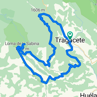
Ruta que sale de tragacete, sube hasta la mogorrita pasando por el pino del Ocejon, baja hasta la pista para coger el Tormo Cañamera para llegar a Tragacete por el nacimiento del Jucar y estrecho del infierno.
Indice IBP 85AB
Fecha: 29-12-2011
- -:--
- Duration
- 36.7 km
- Distance
- 745 m
- Ascent
- 745 m
- Descent
- ---
- Avg. speed
- ---
- Max. altitude

Route quality
Waytypes & surfaces along the route
Waytypes
Track
30.4 km
(83 %)
Road
5.1 km
(14 %)
Surfaces
Unpaved
29.7 km
(81 %)
Ground
21.3 km
(58 %)
Gravel
8.4 km
(23 %)
Undefined
7 km
(19 %)
Continue with Bikemap
Use, edit, or download this cycling route
You would like to ride Tragacete_Mogorrita_TormoCañavera_ or customize it for your own trip? Here is what you can do with this Bikemap route:
Free features
- Save this route as favorite or in collections
- Copy & plan your own version of this route
- Sync your route with Garmin or Wahoo
Premium features
Free trial for 3 days, or one-time payment. More about Bikemap Premium.
- Navigate this route on iOS & Android
- Export a GPX / KML file of this route
- Create your custom printout (try it for free)
- Download this route for offline navigation
Discover more Premium features.
Get Bikemap PremiumFrom our community
Other popular routes starting in Huélamo
 Propuesta Cobardes 2020 - Día 3
- Distance
- 56.1 km
- Ascent
- 2,294 m
- Descent
- 2,294 m
- Location
- Huélamo, Castille-La Mancha, Spain
 Ruta 36 : Serrania de Cuenca ruta 2
- Distance
- 77 km
- Ascent
- 871 m
- Descent
- 1,289 m
- Location
- Huélamo, Castille-La Mancha, Spain
 Etapa 4.-Tragacete-Albarracín
- Distance
- 56.4 km
- Ascent
- 687 m
- Descent
- 862 m
- Location
- Huélamo, Castille-La Mancha, Spain
 Tragacete_Mirador Cuervo, Estrecho Infierno
- Distance
- 38.5 km
- Ascent
- 667 m
- Descent
- 668 m
- Location
- Huélamo, Castille-La Mancha, Spain
 Tragacete_NacimientoJucar_NacimientoCuervo
- Distance
- 30.3 km
- Ascent
- 697 m
- Descent
- 748 m
- Location
- Huélamo, Castille-La Mancha, Spain
 Cobardes2020 - Dia 3, opcion2
- Distance
- 63.2 km
- Ascent
- 1,114 m
- Descent
- 1,214 m
- Location
- Huélamo, Castille-La Mancha, Spain
 Tragacete_Huerta del Marquesado
- Distance
- 31.8 km
- Ascent
- 316 m
- Descent
- 329 m
- Location
- Huélamo, Castille-La Mancha, Spain
 Tragacete_Osquillo_La Bandera
- Distance
- 51.3 km
- Ascent
- 1,079 m
- Descent
- 1,079 m
- Location
- Huélamo, Castille-La Mancha, Spain
Open it in the app