

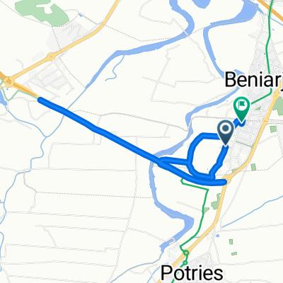
Beniarjo-Benicolet
A cycling route starting in Beniarjó, Valencia, Spain.
Overview
About this route
Ruta de asfalto y cemento, excepto tramo final que es senda de tierra compactada. Ruta técnica y físicamente sencilla.
Se sale de Beniarjó pueblo y la llegada es el centro hípico de Benicolet.
- -:--
- Duration
- 23.2 km
- Distance
- 320 m
- Ascent
- 139 m
- Descent
- ---
- Avg. speed
- ---
- Max. altitude
Route quality
Waytypes & surfaces along the route
Waytypes
Quiet road
6 km
(26 %)
Road
4.2 km
(18 %)
Surfaces
Paved
5.8 km
(25 %)
Paved (undefined)
3.2 km
(14 %)
Asphalt
2.6 km
(11 %)
Undefined
17.4 km
(75 %)
Continue with Bikemap
Use, edit, or download this cycling route
You would like to ride Beniarjo-Benicolet or customize it for your own trip? Here is what you can do with this Bikemap route:
Free features
- Save this route as favorite or in collections
- Copy & plan your own version of this route
- Sync your route with Garmin or Wahoo
Premium features
Free trial for 3 days, or one-time payment. More about Bikemap Premium.
- Navigate this route on iOS & Android
- Export a GPX / KML file of this route
- Create your custom printout (try it for free)
- Download this route for offline navigation
Discover more Premium features.
Get Bikemap PremiumFrom our community
Other popular routes starting in Beniarjó
 Beniarjo-Benicolet
- Distance
- 23.2 km
- Ascent
- 320 m
- Descent
- 139 m
- Location
- Beniarjó, Valencia, Spain
 Beniarjó - Gandía - Marjal de Pego - Denia
- Distance
- 45.1 km
- Ascent
- 164 m
- Descent
- 205 m
- Location
- Beniarjó, Valencia, Spain
 slkjdflask
- Distance
- 42.4 km
- Ascent
- 491 m
- Descent
- 491 m
- Location
- Beniarjó, Valencia, Spain
 Calle del Alcalde Miguel Faus, Beniflá a Calle del Alcalde Miguel Faus, Beniflá
- Distance
- 6.8 km
- Ascent
- 23 m
- Descent
- 26 m
- Location
- Beniarjó, Valencia, Spain
 Ruta de les sureres
- Distance
- 58.8 km
- Ascent
- 643 m
- Descent
- 635 m
- Location
- Beniarjó, Valencia, Spain
 Ruta de les sureres
- Distance
- 58.9 km
- Ascent
- 673 m
- Descent
- 666 m
- Location
- Beniarjó, Valencia, Spain
 Beniarjo-Villalonga-La Llacuna-Almirant-Benirrama-Forna-Oliva
- Distance
- 46.3 km
- Ascent
- 645 m
- Descent
- 644 m
- Location
- Beniarjó, Valencia, Spain
 De ?îm…? a ?îm…?
- Distance
- 3.6 km
- Ascent
- 29 m
- Descent
- 26 m
- Location
- Beniarjó, Valencia, Spain
Open it in the app