

Chattahoochee River Walk
A cycling route starting in Phenix City, Alabama, United States.
Overview
About this route
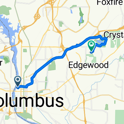
Nice 20+mile route out and back.
Scenery changes from urban river front to woody nature preserve and finally ends on the base of Fort Benning. Can be a fun ride for families at shorter distances as well. Route passes by golf courses, two museums, a nature center, a covered foot bridge, and a couple other bridges over water.
- -:--
- Duration
- 17.4 km
- Distance
- 133 m
- Ascent
- 90 m
- Descent
- ---
- Avg. speed
- ---
- Max. altitude
Route quality
Waytypes & surfaces along the route
Waytypes
Cycleway
16.9 km
(97 %)
Pedestrian area
0.2 km
(<1 %)
Surfaces
Paved
13.8 km
(80 %)
Asphalt
11.3 km
(65 %)
Paved (undefined)
2.4 km
(14 %)
Route highlights
Points of interest along the route
Point of interest after 3.2 km
Head up the hill for the National Civil War Museum
Point of interest after 13.3 km
Ox Bow Meadows Nature Center
Point of interest after 13.6 km
To the left is the National Infantry Museum
Point of interest after 14.4 km
Entry to Fort Benning
Continue with Bikemap
Use, edit, or download this cycling route
You would like to ride Chattahoochee River Walk or customize it for your own trip? Here is what you can do with this Bikemap route:
Free features
- Save this route as favorite or in collections
- Copy & plan your own version of this route
- Sync your route with Garmin or Wahoo
Premium features
Free trial for 3 days, or one-time payment. More about Bikemap Premium.
- Navigate this route on iOS & Android
- Export a GPX / KML file of this route
- Create your custom printout (try it for free)
- Download this route for offline navigation
Discover more Premium features.
Get Bikemap PremiumFrom our community
Other popular routes starting in Phenix City
 Chattahoochee River Walk
- Distance
- 17.4 km
- Ascent
- 133 m
- Descent
- 90 m
- Location
- Phenix City, Alabama, United States
 dddddddddddd
- Distance
- 14.9 km
- Ascent
- 389 m
- Descent
- 411 m
- Location
- Phenix City, Alabama, United States
 15th Street - Pickering Drive
- Distance
- 13.8 km
- Ascent
- 109 m
- Descent
- 93 m
- Location
- Phenix City, Alabama, United States
 Relaxed route in Columbus
- Distance
- 5.9 km
- Ascent
- 79 m
- Descent
- 55 m
- Location
- Phenix City, Alabama, United States
 7961 Oakmont Ct, Columbus to 7965 Oakmont Ct, Columbus
- Distance
- 55.6 km
- Ascent
- 347 m
- Descent
- 340 m
- Location
- Phenix City, Alabama, United States
 Lake Oliver Rd, Columbus to 1001 Front Ave, Columbus
- Distance
- 7.4 km
- Ascent
- 56 m
- Descent
- 91 m
- Location
- Phenix City, Alabama, United States
 west trail Phenix City al
- Distance
- 0.5 km
- Ascent
- 0 m
- Descent
- 9 m
- Location
- Phenix City, Alabama, United States
 7965 Oakmont Ct, Columbus to 7965 Oakmont Ct, Columbus
- Distance
- 40.1 km
- Ascent
- 66 m
- Descent
- 133 m
- Location
- Phenix City, Alabama, United States
Open it in the app