

Krótka runda
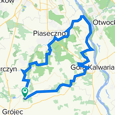
A cycling route starting in Prażmów, Masovian Voivodeship, Poland.
Overview
About this route
A short route of just under 30 km with little elevation gain, ideal for short, light training sessions.
- -:--
- Duration
- 27.8 km
- Distance
- 108 m
- Ascent
- 108 m
- Descent
- ---
- Avg. speed
- ---
- Max. altitude
Route quality
Waytypes & surfaces along the route
Waytypes
Road
10 km
(36 %)
Path
5.8 km
(21 %)
Surfaces
Paved
26.4 km
(95 %)
Asphalt
26.4 km
(95 %)
Undefined
1.4 km
(5 %)
Continue with Bikemap
Use, edit, or download this cycling route
You would like to ride Krótka runda or customize it for your own trip? Here is what you can do with this Bikemap route:
Free features
- Save this route as favorite or in collections
- Copy & plan your own version of this route
- Sync your route with Garmin or Wahoo
Premium features
Free trial for 3 days, or one-time payment. More about Bikemap Premium.
- Navigate this route on iOS & Android
- Export a GPX / KML file of this route
- Create your custom printout (try it for free)
- Download this route for offline navigation
Discover more Premium features.
Get Bikemap PremiumFrom our community
Other popular routes starting in Prażmów
 MILA i seta
- Distance
- 95 km
- Ascent
- 387 m
- Descent
- 388 m
- Location
- Prażmów, Masovian Voivodeship, Poland
 fajnie przez las a później *****
- Distance
- 17.8 km
- Ascent
- 383 m
- Descent
- 349 m
- Location
- Prażmów, Masovian Voivodeship, Poland
 Racibory - Grójec -Białobrzegi - Warka
- Distance
- 108.4 km
- Ascent
- 214 m
- Descent
- 214 m
- Location
- Prażmów, Masovian Voivodeship, Poland
 Zrelaksowana trasa w Łoś
- Distance
- 9 km
- Ascent
- 27 m
- Descent
- 26 m
- Location
- Prażmów, Masovian Voivodeship, Poland
 Krótka runda
- Distance
- 27.8 km
- Ascent
- 108 m
- Descent
- 108 m
- Location
- Prażmów, Masovian Voivodeship, Poland
 Racibory - Mogielnica - Białobrzegi - Racibory
- Distance
- 105.5 km
- Ascent
- 206 m
- Descent
- 206 m
- Location
- Prażmów, Masovian Voivodeship, Poland
 90km, Racibory, Grójec, warka, Racibory.
- Distance
- 96.3 km
- Ascent
- 138 m
- Descent
- 140 m
- Location
- Prażmów, Masovian Voivodeship, Poland
 75km, Racibory -Ksiązęnice - Głuchów - Racibory
- Distance
- 74.3 km
- Ascent
- 119 m
- Descent
- 120 m
- Location
- Prażmów, Masovian Voivodeship, Poland
Open it in the app