
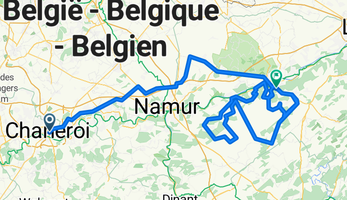
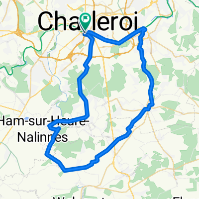
Fleche Wallone 2011
A cycling route starting in Charleroi, Wallonia, Belgium.
Overview
About this route
- -:--
- Duration
- 200.4 km
- Distance
- 1,292 m
- Ascent
- 1,220 m
- Descent
- ---
- Avg. speed
- ---
- Max. altitude

Route quality
Waytypes & surfaces along the route
Waytypes
Quiet road
62.1 km
(31 %)
Road
42.1 km
(21 %)
Surfaces
Paved
96.2 km
(48 %)
Unpaved
4 km
(2 %)
Asphalt
82.2 km
(41 %)
Paved (undefined)
8 km
(4 %)
Continue with Bikemap
Use, edit, or download this cycling route
You would like to ride Fleche Wallone 2011 or customize it for your own trip? Here is what you can do with this Bikemap route:
Free features
- Save this route as favorite or in collections
- Copy & plan your own version of this route
- Split it into stages to create a multi-day tour
- Sync your route with Garmin or Wahoo
Premium features
Free trial for 3 days, or one-time payment. More about Bikemap Premium.
- Navigate this route on iOS & Android
- Export a GPX / KML file of this route
- Create your custom printout (try it for free)
- Download this route for offline navigation
Discover more Premium features.
Get Bikemap PremiumFrom our community
Other popular routes starting in Charleroi
 AllerRetourMSM-Charleroi-parMarchienne
- Distance
- 15.4 km
- Ascent
- 116 m
- Descent
- 108 m
- Location
- Charleroi, Wallonia, Belgium
 circuit 8/11
- Distance
- 42.4 km
- Ascent
- 614 m
- Descent
- 612 m
- Location
- Charleroi, Wallonia, Belgium
 Charleroi Sud - Silenrieux
- Distance
- 23.5 km
- Ascent
- 252 m
- Descent
- 169 m
- Location
- Charleroi, Wallonia, Belgium
 NalinnesLovervalMarcinelle
- Distance
- 19 km
- Ascent
- 224 m
- Descent
- 224 m
- Location
- Charleroi, Wallonia, Belgium
 Charleroi-AAchen
- Distance
- 172.1 km
- Ascent
- 633 m
- Descent
- 552 m
- Location
- Charleroi, Wallonia, Belgium
 Boucle Noire
- Distance
- 20.6 km
- Ascent
- 210 m
- Descent
- 208 m
- Location
- Charleroi, Wallonia, Belgium
 Itinéraire reposant en Montigny-le-Tilleul
- Distance
- 29.7 km
- Ascent
- 390 m
- Descent
- 390 m
- Location
- Charleroi, Wallonia, Belgium
 marcinelle
- Distance
- 48.7 km
- Ascent
- 260 m
- Descent
- 257 m
- Location
- Charleroi, Wallonia, Belgium
Open it in the app