

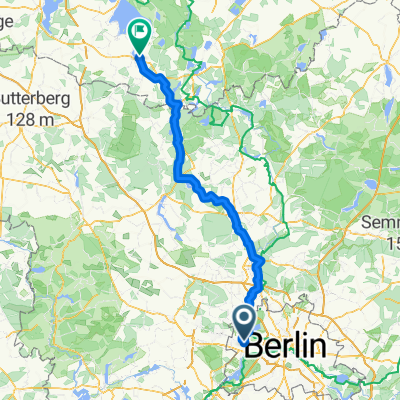
Spandau-Potsdam
A cycling route starting in Spandau, State of Berlin, Germany.
Overview
About this route
- -:--
- Duration
- 31.9 km
- Distance
- 149 m
- Ascent
- 144 m
- Descent
- ---
- Avg. speed
- ---
- Max. altitude

Route quality
Waytypes & surfaces along the route
Waytypes
Quiet road
9.9 km
(31 %)
Path
4.8 km
(15 %)
Surfaces
Paved
23.6 km
(74 %)
Asphalt
23 km
(72 %)
Paved (undefined)
0.3 km
(1 %)
Continue with Bikemap
Use, edit, or download this cycling route
You would like to ride Spandau-Potsdam or customize it for your own trip? Here is what you can do with this Bikemap route:
Free features
- Save this route as favorite or in collections
- Copy & plan your own version of this route
- Sync your route with Garmin or Wahoo
Premium features
Free trial for 3 days, or one-time payment. More about Bikemap Premium.
- Navigate this route on iOS & Android
- Export a GPX / KML file of this route
- Create your custom printout (try it for free)
- Download this route for offline navigation
Discover more Premium features.
Get Bikemap PremiumFrom our community
Other popular routes starting in Spandau
 Durch den Grunewald
- Distance
- 25.5 km
- Ascent
- 284 m
- Descent
- 279 m
- Location
- Spandau, State of Berlin, Germany
 am Havelkanal
- Distance
- 31.3 km
- Ascent
- 74 m
- Descent
- 72 m
- Location
- Spandau, State of Berlin, Germany
 Spandau-Potsdam
- Distance
- 31.9 km
- Ascent
- 149 m
- Descent
- 144 m
- Location
- Spandau, State of Berlin, Germany
 Stadtführung Berlin, Radtour durch die westlichen Randgebiete von www.stadtspiele-verlag.de
- Distance
- 50.5 km
- Ascent
- 166 m
- Descent
- 160 m
- Location
- Spandau, State of Berlin, Germany
 Rathaus Spandau - Sacrower Schlosspark und zurück
- Distance
- 48.1 km
- Ascent
- 134 m
- Descent
- 136 m
- Location
- Spandau, State of Berlin, Germany
 Spandau Runde
- Distance
- 9.3 km
- Ascent
- 34 m
- Descent
- 31 m
- Location
- Spandau, State of Berlin, Germany
 Berlin-Tour
- Distance
- 651.5 km
- Ascent
- 195 m
- Descent
- 230 m
- Location
- Spandau, State of Berlin, Germany
 Altstädter Ring, Berlin nach Müritzstraße, Rechlin
- Distance
- 129.8 km
- Ascent
- 563 m
- Descent
- 534 m
- Location
- Spandau, State of Berlin, Germany
Open it in the app