

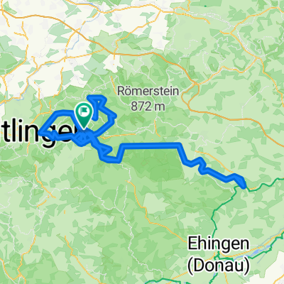
Schwäbische Alp-Tour2
A cycling route starting in Bad Urach, Baden-Wurttemberg, Germany.
Overview
About this route
- -:--
- Duration
- 67.4 km
- Distance
- 1,271 m
- Ascent
- 1,172 m
- Descent
- ---
- Avg. speed
- 820 m
- Max. altitude

Route quality
Waytypes & surfaces along the route
Waytypes
Track
22.9 km
(34 %)
Quiet road
14.8 km
(22 %)
Surfaces
Paved
57.3 km
(85 %)
Unpaved
0.7 km
(1 %)
Asphalt
48.5 km
(72 %)
Paved (undefined)
4.7 km
(7 %)
Continue with Bikemap
Use, edit, or download this cycling route
You would like to ride Schwäbische Alp-Tour2 or customize it for your own trip? Here is what you can do with this Bikemap route:
Free features
- Save this route as favorite or in collections
- Copy & plan your own version of this route
- Sync your route with Garmin or Wahoo
Premium features
Free trial for 3 days, or one-time payment. More about Bikemap Premium.
- Navigate this route on iOS & Android
- Export a GPX / KML file of this route
- Create your custom printout (try it for free)
- Download this route for offline navigation
Discover more Premium features.
Get Bikemap PremiumFrom our community
Other popular routes starting in Bad Urach
 Schwäbische Alp-Tour1
- Distance
- 96 km
- Ascent
- 1,446 m
- Descent
- 1,280 m
- Location
- Bad Urach, Baden-Wurttemberg, Germany
 201910 Bad Urach
- Distance
- 214.6 km
- Ascent
- 4,262 m
- Descent
- 4,259 m
- Location
- Bad Urach, Baden-Wurttemberg, Germany
 Genusstourüber die Schwäbische Alb
- Distance
- 31.2 km
- Ascent
- 290 m
- Descent
- 303 m
- Location
- Bad Urach, Baden-Wurttemberg, Germany
 Trailfingen - Lenniger Tal
- Distance
- 69.2 km
- Ascent
- 678 m
- Descent
- 679 m
- Location
- Bad Urach, Baden-Wurttemberg, Germany
 Auf der Alb
- Distance
- 31.3 km
- Ascent
- 500 m
- Descent
- 487 m
- Location
- Bad Urach, Baden-Wurttemberg, Germany
 Schwäbische Alp-Tour2
- Distance
- 67.4 km
- Ascent
- 1,271 m
- Descent
- 1,172 m
- Location
- Bad Urach, Baden-Wurttemberg, Germany
 20220914 Esslingen a
- Distance
- 61.6 km
- Ascent
- 635 m
- Descent
- 828 m
- Location
- Bad Urach, Baden-Wurttemberg, Germany
 Route zu Gasthaus Pfählhof
- Distance
- 10.4 km
- Ascent
- 582 m
- Descent
- 582 m
- Location
- Bad Urach, Baden-Wurttemberg, Germany
Open it in the app