

5.gurera
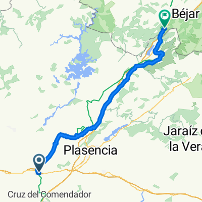
A cycling route starting in Galisteo, Extremadura, Spain.
Overview
About this route
Things to do. Hostels?
- -:--
- Duration
- 90.6 km
- Distance
- 1,184 m
- Ascent
- 664 m
- Descent
- ---
- Avg. speed
- 902 m
- Max. altitude

Route quality
Waytypes & surfaces along the route
Waytypes
Track
29.9 km
(33 %)
Cycleway
19 km
(21 %)
Surfaces
Paved
23.6 km
(26 %)
Unpaved
21.7 km
(24 %)
Gravel
18.1 km
(20 %)
Asphalt
16.3 km
(18 %)
Route highlights
Points of interest along the route
Point of interest after 90.2 km
ostatua
Point of interest after 90.6 km
piedrafita
Continue with Bikemap
Use, edit, or download this cycling route
You would like to ride 5.gurera or customize it for your own trip? Here is what you can do with this Bikemap route:
Free features
- Save this route as favorite or in collections
- Copy & plan your own version of this route
- Split it into stages to create a multi-day tour
- Sync your route with Garmin or Wahoo
Premium features
Free trial for 3 days, or one-time payment. More about Bikemap Premium.
- Navigate this route on iOS & Android
- Export a GPX / KML file of this route
- Create your custom printout (try it for free)
- Download this route for offline navigation
Discover more Premium features.
Get Bikemap PremiumFrom our community
Other popular routes starting in Galisteo
 From Galisteo to Puerto de Béjar
- Distance
- 71.5 km
- Ascent
- 1,077 m
- Descent
- 431 m
- Location
- Galisteo, Extremadura, Spain
 Galisteo - El Barco de Avila
- Distance
- 106.3 km
- Ascent
- 1,287 m
- Descent
- 564 m
- Location
- Galisteo, Extremadura, Spain
 Via de la Plata 7. Galisteo - Puerto de Bejar
- Distance
- 73.5 km
- Ascent
- 821 m
- Descent
- 183 m
- Location
- Galisteo, Extremadura, Spain
 2019-10-20
- Distance
- 75.7 km
- Ascent
- 1,211 m
- Descent
- 715 m
- Location
- Galisteo, Extremadura, Spain
 Galistéo - Banos de Montmayor
- Distance
- 69.4 km
- Ascent
- 631 m
- Descent
- 226 m
- Location
- Galisteo, Extremadura, Spain
 Ruta de la Plata - Galisteo-Puerto de Bejar
- Distance
- 67.9 km
- Ascent
- 853 m
- Descent
- 212 m
- Location
- Galisteo, Extremadura, Spain
 5.gurera
- Distance
- 90.6 km
- Ascent
- 1,184 m
- Descent
- 664 m
- Location
- Galisteo, Extremadura, Spain
 Circular-Alagón-Valrio-Morcillo-Batán-Holguera-Grimaldo-Riolobos-Galisteo
- Distance
- 66.1 km
- Ascent
- 505 m
- Descent
- 505 m
- Location
- Galisteo, Extremadura, Spain
Open it in the app