
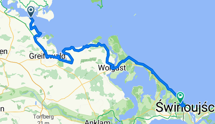
Stahlbrode – Greifswald – Lubmin – Wolgast – Ahlbeck
A cycling route starting in Poseritz, Mecklenburg-Vorpommern, Germany.
Overview
About this route
<span style="mso-ansi-language: DE;">Von Stahlbrode ging es über Feldwege teilweise an der Ostsee entlang bis Riemserort. Jetzt ging es Richtung Bundesstraße um dann über die alte Kopfsteinpflaster Straße nach Greifswald zu gelangen. Nach einer kleinen Runde durch die Stadt ging es an der Ryck entlang nach Wieck. Über die Hafenbrücke in den Ort zu einer Aussicht zur See ging es wieder zurück um weiter zu gelangen. Über </span> <span style="font-size: 11.0pt; line-height: 115%; font-family: "Calibri","sans-serif"; mso-ascii-theme-font: minor-latin; mso-fareast-font-family: "Times New Roman"; mso-fareast-theme-font: minor-fareast; mso-hansi-theme-font: minor-latin; mso-bidi-font-family: "Times New Roman"; mso-bidi-theme-font: minor-bidi; mso-ansi-language: DE; mso-fareast-language: EN-US; mso-bidi-language: EN-US;">Kemnitz und Ludwigsburg ging es nach Lubmin rein. Am KKW Nord vorbei ging es über Freest und Kröslin nach Wolgast. Über eine Brücke ging es auf die Insel Usedom. Durch Mölschow und hinter Trassenheide ging es immer in unmittelbarer Nähe der Ostsee durch die bekannten Badeorte Zinnowitz, Koserow, Bansin und Heringsdorf nach Ahlbeck. Noch vor Swinoujscie machte ich kehrt und auf die<span style="mso-spacerun: yes;"> </span>Suche nach einem möglichen Platz zum Übernachten.</span>
- -:--
- Duration
- 123.9 km
- Distance
- 245 m
- Ascent
- 199 m
- Descent
- ---
- Avg. speed
- ---
- Avg. speed
Route quality
Waytypes & surfaces along the route
Waytypes
Path
45.3 km
(37 %)
Quiet road
30.1 km
(24 %)
Surfaces
Paved
77.1 km
(62 %)
Unpaved
24.8 km
(20 %)
Asphalt
54.4 km
(44 %)
Paving stones
15.6 km
(13 %)
Continue with Bikemap
Use, edit, or download this cycling route
You would like to ride Stahlbrode – Greifswald – Lubmin – Wolgast – Ahlbeck or customize it for your own trip? Here is what you can do with this Bikemap route:
Free features
- Save this route as favorite or in collections
- Copy & plan your own version of this route
- Split it into stages to create a multi-day tour
- Sync your route with Garmin or Wahoo
Premium features
Free trial for 3 days, or one-time payment. More about Bikemap Premium.
- Navigate this route on iOS & Android
- Export a GPX / KML file of this route
- Create your custom printout (try it for free)
- Download this route for offline navigation
Discover more Premium features.
Get Bikemap PremiumFrom our community
Other popular routes starting in Poseritz
 Stahlbrode 96, Sundhagen nach Stahlbrode 96, Sundhagen
- Distance
- 57.6 km
- Ascent
- 233 m
- Descent
- 234 m
- Location
- Poseritz, Mecklenburg-Vorpommern, Germany
 Ostsee-Radweg Tag 8.
- Distance
- 94.4 km
- Ascent
- 137 m
- Descent
- 132 m
- Location
- Poseritz, Mecklenburg-Vorpommern, Germany
 Dom-Gustow-Altefar-Rambin-Klein Kubitz-?-Samtens
- Distance
- 66.5 km
- Ascent
- 146 m
- Descent
- 145 m
- Location
- Poseritz, Mecklenburg-Vorpommern, Germany
 Dom-Raja imbis-Rest-Dom
- Distance
- 20.2 km
- Ascent
- 60 m
- Descent
- 59 m
- Location
- Poseritz, Mecklenburg-Vorpommern, Germany
 Poseritz-Stralsund
- Distance
- 15.6 km
- Ascent
- 52 m
- Descent
- 67 m
- Location
- Poseritz, Mecklenburg-Vorpommern, Germany
 Stahlbrode - Demmin
- Distance
- 48.6 km
- Ascent
- 45 m
- Descent
- 44 m
- Location
- Poseritz, Mecklenburg-Vorpommern, Germany
 Gustow (um Poseritz)
- Distance
- 27.8 km
- Ascent
- 75 m
- Descent
- 72 m
- Location
- Poseritz, Mecklenburg-Vorpommern, Germany
 Dom-Pitbus-Altensien
- Distance
- 79.5 km
- Ascent
- 530 m
- Descent
- 529 m
- Location
- Poseritz, Mecklenburg-Vorpommern, Germany
Open it in the app