

20231007_グランフォンドいばらき 2023【B ひたち海浜シーサイドライド(中辛)】
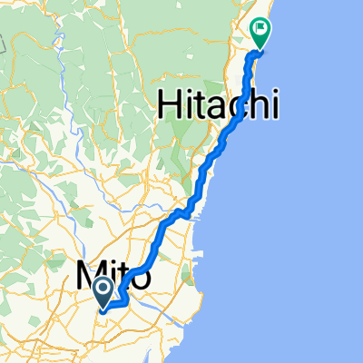
A cycling route starting in Mito, Ibaraki, Japan.
Overview
About this route
RwGPS 96.1km +681m/-683m 【グランフォンドイバラキ】 official MAP Download
Hitachi Seaside B Course (97km) to Ibaraki Airport
-
Start at Mito Station
-
Kurozawa Soy Sauce Shop (Aid)
-
Hitachi Seaside Park (Aid)
-
Hoshiimo Shrine (Spot)
-
Oarai Beach (Aid, Spot)
-
Oarai Sunset Village Matsukawa (Aid)
-
Ibaraki Airport (Spot)
-
Sky Station Sorara (Aid)
-
Finish at Mito Station
- 6 h 54 min
- Duration
- 96.4 km
- Distance
- 468 m
- Ascent
- 465 m
- Descent
- 14 km/h
- Avg. speed
- 38 m
- Max. altitude

Route photos
】\"")
】\"")
】\"")
】\"")
】\"")
Route quality
Waytypes & surfaces along the route
Waytypes
Road
20.2 km
(21 %)
Quiet road
15.4 km
(16 %)
Surfaces
Paved
54.9 km
(57 %)
Asphalt
47.2 km
(49 %)
Paved (undefined)
7.7 km
(8 %)
Undefined
41.5 km
(43 %)
Continue with Bikemap
Use, edit, or download this cycling route
You would like to ride 20231007_グランフォンドいばらき 2023【B ひたち海浜シーサイドライド(中辛)】 or customize it for your own trip? Here is what you can do with this Bikemap route:
Free features
- Save this route as favorite or in collections
- Copy & plan your own version of this route
- Split it into stages to create a multi-day tour
- Sync your route with Garmin or Wahoo
Premium features
Free trial for 3 days, or one-time payment. More about Bikemap Premium.
- Navigate this route on iOS & Android
- Export a GPX / KML file of this route
- Create your custom printout (try it for free)
- Download this route for offline navigation
Discover more Premium features.
Get Bikemap PremiumFrom our community
Other popular routes starting in Mito
 水戸駅→大洗キャンプ場
- Distance
- 13.2 km
- Ascent
- 43 m
- Descent
- 24 m
- Location
- Mito, Ibaraki, Japan
 20231007_グランフォンドいばらき 2023【B ひたち海浜シーサイドライド(中辛)】
- Distance
- 96.4 km
- Ascent
- 468 m
- Descent
- 465 m
- Location
- Mito, Ibaraki, Japan
 千波湖周辺
千波湖周辺- Distance
- 3.6 km
- Ascent
- 18 m
- Descent
- 19 m
- Location
- Mito, Ibaraki, Japan
 mito-immigration
- Distance
- 0.6 km
- Ascent
- 0 m
- Descent
- 0 m
- Location
- Mito, Ibaraki, Japan
 Route to 田町, いわき市
- Distance
- 105.3 km
- Ascent
- 531 m
- Descent
- 616 m
- Location
- Mito, Ibaraki, Japan
 千波町, 水戸市へ有明町3丁目, 高萩市
- Distance
- 62.2 km
- Ascent
- 443 m
- Descent
- 471 m
- Location
- Mito, Ibaraki, Japan
 下市ルート
下市ルート- Distance
- 8.7 km
- Ascent
- 45 m
- Descent
- 46 m
- Location
- Mito, Ibaraki, Japan
 Senbako & Sakuragawa
- Distance
- 9.5 km
- Ascent
- 233 m
- Descent
- 231 m
- Location
- Mito, Ibaraki, Japan
Open it in the app