

Gador - Ricaveral - Estacion Fuente Santa
A cycling route starting in Gádor, Andalusia, Spain.
Overview
About this route
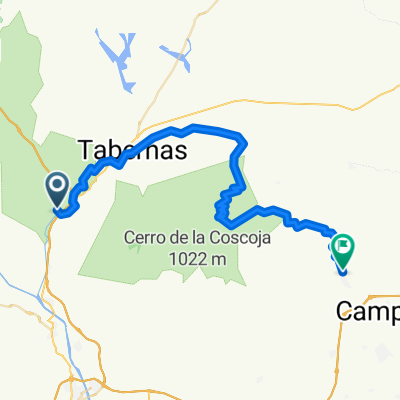
Start from Gador via the asphalt road of Paulenca until <strong>km 5</strong> in Santa Fe. In Santa Fe, we pass the village along the Andarax until the rambla de Gergal where we start to climb the rambla de Gergal. At <strong>km 8</strong> we take a left detour marked with a sign for the GR-140 'Alhabia'. At <strong>km 11</strong> we will reach the A-3407 (Ricaveral) road which we will climb. (DANGER: VERY BUSY AREA FOR MOTORCYCLES) At <strong>km 12.5</strong> we will turn right where there is a wooden sign 'Ermita de la Rambla de Gergal'. Be especially cautious starting from <strong>km 14</strong> where the descent becomes very technical with loose stones. Once we take the rambla de Gergal again at <strong>km 15</strong>, we will follow it northwards. At approximately <strong>km 20</strong> we will find a house built on a small hill on the right, we will take that detour to the right. At approximately <strong>km 22</strong> we will arrive at the Fuente Santa Station where we will cross the tracks taking a path where several beams cut across it, and following that trail until we reach the Rambla de Tabernas. At around <strong>km 32</strong> we will arrive at the rambla de Tabernas, which we will follow downward to the Paulenca <strong>km 39</strong> where we will detour to the right until we arrive at Gador.
- -:--
- Duration
- 41.2 km
- Distance
- 582 m
- Ascent
- 580 m
- Descent
- ---
- Avg. speed
- ---
- Max. altitude

Route highlights
Points of interest along the route
Point of interest after 8.3 km
Desvío indicado como sendero GR-14 dirección Alhabia.
Point of interest after 20.1 km
Desvio a la derecha, no existe indicación. Hay una casa en la esquina sobre un pequeño cerro.
Point of interest after 21.9 km
Cruzar las vias del tren.
Continue with Bikemap
Use, edit, or download this cycling route
You would like to ride Gador - Ricaveral - Estacion Fuente Santa or customize it for your own trip? Here is what you can do with this Bikemap route:
Free features
- Save this route as favorite or in collections
- Copy & plan your own version of this route
- Sync your route with Garmin or Wahoo
Premium features
Free trial for 3 days, or one-time payment. More about Bikemap Premium.
- Navigate this route on iOS & Android
- Export a GPX / KML file of this route
- Create your custom printout (try it for free)
- Download this route for offline navigation
Discover more Premium features.
Get Bikemap PremiumFrom our community
Other popular routes starting in Gádor
 Ruta cinematográfica Tabernas
- Distance
- 41.7 km
- Ascent
- 570 m
- Descent
- 570 m
- Location
- Gádor, Andalusia, Spain
 GÁDOR-Estación Fuensanta
- Distance
- 39.3 km
- Ascent
- 543 m
- Descent
- 544 m
- Location
- Gádor, Andalusia, Spain
 Gador - Ricaveral - Estacion Fuente Santa
- Distance
- 41.2 km
- Ascent
- 582 m
- Descent
- 580 m
- Location
- Gádor, Andalusia, Spain
 Gador - Estación Sta. Fe - Arbol del Ahorcado
- Distance
- 35.6 km
- Ascent
- 504 m
- Descent
- 504 m
- Location
- Gádor, Andalusia, Spain
 Gádor-Alhama-vereas II
- Distance
- 32.6 km
- Ascent
- 911 m
- Descent
- 911 m
- Location
- Gádor, Andalusia, Spain
 Gádor-Cerro del Cuchillo-La Veguilla-Puente mocho-Piedra lisa-Gádor
- Distance
- 30.9 km
- Ascent
- 998 m
- Descent
- 995 m
- Location
- Gádor, Andalusia, Spain
 Gádor - Tabernas
- Distance
- 17.3 km
- Ascent
- 327 m
- Descent
- 83 m
- Location
- Gádor, Andalusia, Spain
 Gádor - Níjar
- Distance
- 52.6 km
- Ascent
- 1,114 m
- Descent
- 986 m
- Location
- Gádor, Andalusia, Spain
Open it in the app