
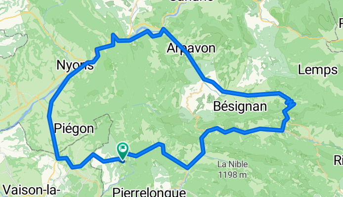
F/Propiac-Mirabel-Gouvernet-ret
A cycling route starting in Buis-les-Baronnies, Auvergne-Rhône-Alpes, France.
Overview
About this route
Great ride
- -:--
- Duration
- 75.8 km
- Distance
- 753 m
- Ascent
- 781 m
- Descent
- ---
- Avg. speed
- ---
- Max. altitude

Route quality
Waytypes & surfaces along the route
Waytypes
Road
18.2 km
(24 %)
Quiet road
7.6 km
(10 %)
Surfaces
Paved
18.2 km
(24 %)
Unpaved
6.1 km
(8 %)
Asphalt
18.2 km
(24 %)
Gravel
4.5 km
(6 %)
Continue with Bikemap
Use, edit, or download this cycling route
You would like to ride F/Propiac-Mirabel-Gouvernet-ret or customize it for your own trip? Here is what you can do with this Bikemap route:
Free features
- Save this route as favorite or in collections
- Copy & plan your own version of this route
- Sync your route with Garmin or Wahoo
Premium features
Free trial for 3 days, or one-time payment. More about Bikemap Premium.
- Navigate this route on iOS & Android
- Export a GPX / KML file of this route
- Create your custom printout (try it for free)
- Download this route for offline navigation
Discover more Premium features.
Get Bikemap PremiumFrom our community
Other popular routes starting in Buis-les-Baronnies
 Mont-Ventoux par Sault
- Distance
- 100.2 km
- Ascent
- 1,940 m
- Descent
- 1,936 m
- Location
- Buis-les-Baronnies, Auvergne-Rhône-Alpes, France
 boucle Buis, col de Fontaube, Savoillan
- Distance
- 54.8 km
- Ascent
- 760 m
- Descent
- 760 m
- Location
- Buis-les-Baronnies, Auvergne-Rhône-Alpes, France
 F/Propiac-Mirabel-Gouvernet-ret
- Distance
- 75.8 km
- Ascent
- 753 m
- Descent
- 781 m
- Location
- Buis-les-Baronnies, Auvergne-Rhône-Alpes, France
 Circuit 3 Buis - Gorges de la Nesque - Buis par Malaucène
- Distance
- 122 km
- Ascent
- 1,099 m
- Descent
- 1,097 m
- Location
- Buis-les-Baronnies, Auvergne-Rhône-Alpes, France
 Circuit 2 Buis, Col Perty, col St. Jean, Buis
- Distance
- 90.2 km
- Ascent
- 1,371 m
- Descent
- 1,374 m
- Location
- Buis-les-Baronnies, Auvergne-Rhône-Alpes, France
 Test
Test- Distance
- 43.8 km
- Ascent
- 668 m
- Descent
- 669 m
- Location
- Buis-les-Baronnies, Auvergne-Rhône-Alpes, France
 BlB, CdE, CdS, Nyons, BlB
- Distance
- 92.5 km
- Ascent
- 1,175 m
- Descent
- 1,175 m
- Location
- Buis-les-Baronnies, Auvergne-Rhône-Alpes, France
 Drôme : Buis - Malaucène - Ventoux - Sault - Aulan - Buis
- Distance
- 112.2 km
- Ascent
- 1,895 m
- Descent
- 1,895 m
- Location
- Buis-les-Baronnies, Auvergne-Rhône-Alpes, France
Open it in the app