

PICO DEL AGUILA-ALMEDIJAR-ORONET N
A cycling route starting in Alboraya, Valencia, Spain.
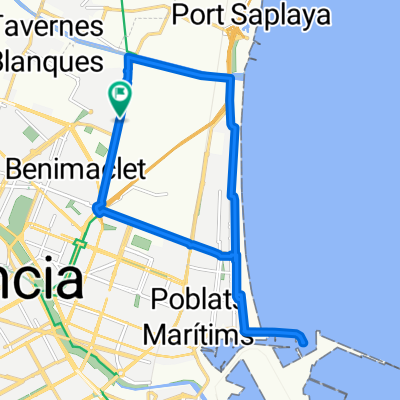
Overview
About this route
- 23 h 1 min
- Duration
- 138.6 km
- Distance
- 2,381 m
- Ascent
- 2,370 m
- Descent
- 6 km/h
- Avg. speed
- 782 m
- Max. altitude

Route quality
Waytypes & surfaces along the route
Waytypes
Busy road
69.2 km
(50 %)
Road
25 km
(18 %)
Surfaces
Paved
12.8 km
(9 %)
Unpaved
5.2 km
(4 %)
Asphalt
9.3 km
(7 %)
Gravel
4.2 km
(3 %)
Continue with Bikemap
Use, edit, or download this cycling route
You would like to ride PICO DEL AGUILA-ALMEDIJAR-ORONET N or customize it for your own trip? Here is what you can do with this Bikemap route:
Free features
- Save this route as favorite or in collections
- Copy & plan your own version of this route
- Split it into stages to create a multi-day tour
- Sync your route with Garmin or Wahoo
Premium features
Free trial for 3 days, or one-time payment. More about Bikemap Premium.
- Navigate this route on iOS & Android
- Export a GPX / KML file of this route
- Create your custom printout (try it for free)
- Download this route for offline navigation
Discover more Premium features.
Get Bikemap PremiumFrom our community
Other popular routes starting in Alboraya
 Valencia - Mola de Segart - Chocainet -Valencia
- Distance
- 56.4 km
- Ascent
- 640 m
- Descent
- 639 m
- Location
- Alboraya, Valencia, Spain
 Route 2 Valencia
- Distance
- 58.7 km
- Ascent
- 0 m
- Descent
- 0 m
- Location
- Alboraya, Valencia, Spain
 alboraya,puerto,malvarrosa,alboraya
- Distance
- 15.4 km
- Ascent
- 34 m
- Descent
- 34 m
- Location
- Alboraya, Valencia, Spain
 Valencia-Sot de Chera
- Distance
- 216.8 km
- Ascent
- 1,702 m
- Descent
- 1,707 m
- Location
- Alboraya, Valencia, Spain
 Valencia - Xativa
- Distance
- 78.5 km
- Ascent
- 146 m
- Descent
- 38 m
- Location
- Alboraya, Valencia, Spain
 20100616-Por la costa
- Distance
- 43.7 km
- Ascent
- 156 m
- Descent
- 43 m
- Location
- Alboraya, Valencia, Spain
 Valencia-Gandía-Alcoi
- Distance
- 122.2 km
- Ascent
- 761 m
- Descent
- 208 m
- Location
- Alboraya, Valencia, Spain
 Valencia-Sot de Chera
- Distance
- 199.1 km
- Ascent
- 1,283 m
- Descent
- 1,284 m
- Location
- Alboraya, Valencia, Spain
Open it in the app