

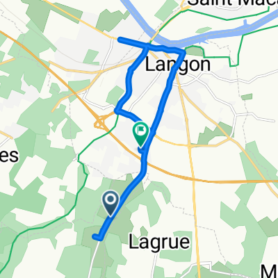
st.Maixent
A cycling route starting in Langon, Nouvelle-Aquitaine, France.
Overview
About this route
- -:--
- Duration
- 4.3 km
- Distance
- 11 m
- Ascent
- 23 m
- Descent
- ---
- Avg. speed
- 21 m
- Max. altitude
Route quality
Waytypes & surfaces along the route
Waytypes
Quiet road
2.3 km
(55 %)
Cycleway
1.1 km
(25 %)
Undefined
0.9 km
(20 %)
Surfaces
Paved
0.8 km
(19 %)
Asphalt
0.8 km
(19 %)
Undefined
3.5 km
(81 %)
Continue with Bikemap
Use, edit, or download this cycling route
You would like to ride st.Maixent or customize it for your own trip? Here is what you can do with this Bikemap route:
Free features
- Save this route as favorite or in collections
- Copy & plan your own version of this route
- Sync your route with Garmin or Wahoo
Premium features
Free trial for 3 days, or one-time payment. More about Bikemap Premium.
- Navigate this route on iOS & Android
- Export a GPX / KML file of this route
- Create your custom printout (try it for free)
- Download this route for offline navigation
Discover more Premium features.
Get Bikemap PremiumFrom our community
Other popular routes starting in Langon
 Langon Perigueux
- Distance
- 131.9 km
- Ascent
- 525 m
- Descent
- 421 m
- Location
- Langon, Nouvelle-Aquitaine, France
 Itinéraire à partir de D222, Roaillan
- Distance
- 10 km
- Ascent
- 59 m
- Descent
- 65 m
- Location
- Langon, Nouvelle-Aquitaine, France
 Landas 11 Dia 5.0
- Distance
- 45.7 km
- Ascent
- 64 m
- Descent
- 78 m
- Location
- Langon, Nouvelle-Aquitaine, France
 127 Cours Gambetta, Langon to Place Rohan, Bordeaux
- Distance
- 47.8 km
- Ascent
- 111 m
- Descent
- 117 m
- Location
- Langon, Nouvelle-Aquitaine, France
 De 7bis Lotissement La Prairie, Langon à 51 Mounens, Castets-en-Dorthe
- Distance
- 120.8 km
- Ascent
- 53 m
- Descent
- 68 m
- Location
- Langon, Nouvelle-Aquitaine, France
 02 Langon to Agen 98
- Distance
- 98 km
- Ascent
- 568 m
- Descent
- 543 m
- Location
- Langon, Nouvelle-Aquitaine, France
 TDF - E20
- Distance
- 44.7 km
- Ascent
- 100 m
- Descent
- 115 m
- Location
- Langon, Nouvelle-Aquitaine, France
 langon gujan
- Distance
- 80.5 km
- Ascent
- 134 m
- Descent
- 149 m
- Location
- Langon, Nouvelle-Aquitaine, France
Open it in the app