
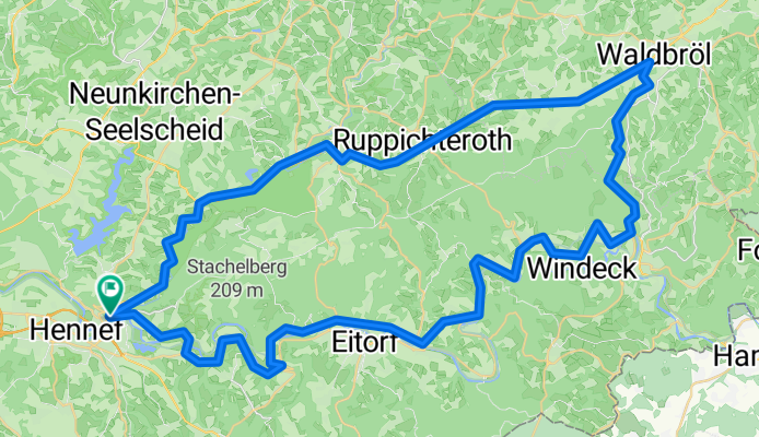
Bröltal - Siegtal Runde
A cycling route starting in Hennef, North Rhine-Westphalia, Germany.
Overview
About this route
Startpunkt Hennef Eingangs Bröltal
über Ruppichteroth - Waldbröl
Hinunter nach Schladern
über Dattenfeld - Herchen
über den Berg nach Eitorf
durchs Siegtal bis zum Ausgangspunkt
- -:--
- Duration
- 71.7 km
- Distance
- 703 m
- Ascent
- 694 m
- Descent
- ---
- Avg. speed
- 339 m
- Max. altitude
Route quality
Waytypes & surfaces along the route
Waytypes
Busy road
38.1 km
(53 %)
Path
17.1 km
(24 %)
Surfaces
Paved
58.7 km
(82 %)
Unpaved
0.3 km
(<1 %)
Asphalt
56.5 km
(79 %)
Paving stones
1.6 km
(2 %)
Continue with Bikemap
Use, edit, or download this cycling route
You would like to ride Bröltal - Siegtal Runde or customize it for your own trip? Here is what you can do with this Bikemap route:
Free features
- Save this route as favorite or in collections
- Copy & plan your own version of this route
- Sync your route with Garmin or Wahoo
Premium features
Free trial for 3 days, or one-time payment. More about Bikemap Premium.
- Navigate this route on iOS & Android
- Export a GPX / KML file of this route
- Create your custom printout (try it for free)
- Download this route for offline navigation
Discover more Premium features.
Get Bikemap PremiumFrom our community
Other popular routes starting in Hennef
 Große Runde um Hennef
- Distance
- 57.8 km
- Ascent
- 566 m
- Descent
- 566 m
- Location
- Hennef, North Rhine-Westphalia, Germany
 CTF "CITO" Kurzstrecke
- Distance
- 35.7 km
- Ascent
- 474 m
- Descent
- 474 m
- Location
- Hennef, North Rhine-Westphalia, Germany
 Pfannkuchenmühlen-Route
- Distance
- 47.2 km
- Ascent
- 485 m
- Descent
- 494 m
- Location
- Hennef, North Rhine-Westphalia, Germany
 Erlebnissweg Talsperrenweg
- Distance
- 23.6 km
- Ascent
- 455 m
- Descent
- 455 m
- Location
- Hennef, North Rhine-Westphalia, Germany
 2025-01 Hennef bis Düren
- Distance
- 80.6 km
- Ascent
- 232 m
- Descent
- 170 m
- Location
- Hennef, North Rhine-Westphalia, Germany
 Manni´s Krabachstrecke
- Distance
- 40.2 km
- Ascent
- 526 m
- Descent
- 519 m
- Location
- Hennef, North Rhine-Westphalia, Germany
 Wahnbachtalsperre
- Distance
- 57.7 km
- Ascent
- 215 m
- Descent
- 218 m
- Location
- Hennef, North Rhine-Westphalia, Germany
 wahnbachtlsperre
- Distance
- 5.7 km
- Ascent
- 147 m
- Descent
- 149 m
- Location
- Hennef, North Rhine-Westphalia, Germany
Open it in the app