

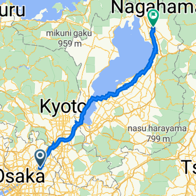
金剛山Light
A cycling route starting in Hirakata, Osaka, Japan.
Overview
About this route
- -:--
- Duration
- 115.2 km
- Distance
- 767 m
- Ascent
- 757 m
- Descent
- ---
- Avg. speed
- ---
- Max. altitude

Continue with Bikemap
Use, edit, or download this cycling route
You would like to ride 金剛山Light or customize it for your own trip? Here is what you can do with this Bikemap route:
Free features
- Save this route as favorite or in collections
- Copy & plan your own version of this route
- Split it into stages to create a multi-day tour
- Sync your route with Garmin or Wahoo
Premium features
Free trial for 3 days, or one-time payment. More about Bikemap Premium.
- Navigate this route on iOS & Android
- Export a GPX / KML file of this route
- Create your custom printout (try it for free)
- Download this route for offline navigation
Discover more Premium features.
Get Bikemap PremiumFrom our community
Other popular routes starting in Hirakata
 10, 枚方市 to 2丁目 1, 枚方市
- Distance
- 41.7 km
- Ascent
- 219 m
- Descent
- 228 m
- Location
- Hirakata, Osaka, Japan
 koyasan-ouro
- Distance
- 93.9 km
- Ascent
- 1,307 m
- Descent
- 636 m
- Location
- Hirakata, Osaka, Japan
 5丁目 20, 枚方市から彦根長浜市
- Distance
- 121.8 km
- Ascent
- 549 m
- Descent
- 453 m
- Location
- Hirakata, Osaka, Japan
 金剛山Light
- Distance
- 115.2 km
- Ascent
- 767 m
- Descent
- 757 m
- Location
- Hirakata, Osaka, Japan
 09-05-2013_Day02
- Distance
- 100.9 km
- Ascent
- 919 m
- Descent
- 846 m
- Location
- Hirakata, Osaka, Japan
 5丁目 16, 枚方市 まで5丁目 16, 枚方市
- Distance
- 56.8 km
- Ascent
- 1,359 m
- Descent
- 1,359 m
- Location
- Hirakata, Osaka, Japan
 府道13号, Hirakata-Shi to 6-2, Shinkitano 2-Chōme, Yodogawa-Ku, Osaka-Shi
- Distance
- 20.8 km
- Ascent
- 0 m
- Descent
- 16 m
- Location
- Hirakata, Osaka, Japan
 5丁目 20, 枚方市 まで宇陀市 宇陀松山城
- Distance
- 59.6 km
- Ascent
- 1,057 m
- Descent
- 636 m
- Location
- Hirakata, Osaka, Japan
Open it in the app