
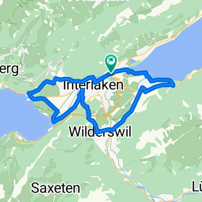
Lanzenen 5, Interlaken nach Untere Bönigstrasse 3, Interlaken
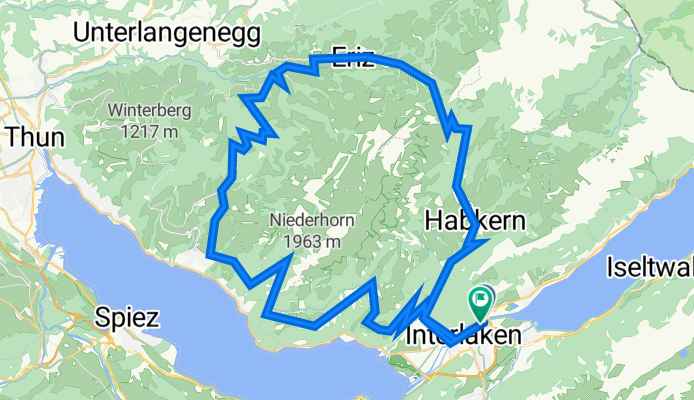
A cycling route starting in Interlaken, Canton of Bern, Switzerland.
Overview
About this route
- 7 h 54 min
- Duration
- 64.9 km
- Distance
- 1,898 m
- Ascent
- 1,885 m
- Descent
- 8.2 km/h
- Avg. speed
- 1,578 m
- Max. altitude

Route photos


Route quality
Waytypes & surfaces along the route
Waytypes
Quiet road
32.5 km
(50 %)
Road
24.7 km
(38 %)
Surfaces
Paved
33.8 km
(52 %)
Unpaved
6.5 km
(10 %)
Asphalt
33.8 km
(52 %)
Gravel
5.2 km
(8 %)
Continue with Bikemap
Use, edit, or download this cycling route
You would like to ride Lanzenen 5, Interlaken nach Untere Bönigstrasse 3, Interlaken or customize it for your own trip? Here is what you can do with this Bikemap route:
Free features
- Save this route as favorite or in collections
- Copy & plan your own version of this route
- Sync your route with Garmin or Wahoo
Premium features
Free trial for 3 days, or one-time payment. More about Bikemap Premium.
- Navigate this route on iOS & Android
- Export a GPX / KML file of this route
- Create your custom printout (try it for free)
- Download this route for offline navigation
Discover more Premium features.
Get Bikemap PremiumFrom our community
Other popular routes starting in Interlaken
 Lanzenen 5, Interlaken nach Untere Bönigstrasse 3, Interlaken
- Distance
- 64.9 km
- Ascent
- 1,898 m
- Descent
- 1,885 m
- Location
- Interlaken, Canton of Bern, Switzerland
 Interlaken - Grindelwald - Interlaken
- Distance
- 102 km
- Ascent
- 3,054 m
- Descent
- 3,046 m
- Location
- Interlaken, Canton of Bern, Switzerland
 Grosse Scheidegg
- Distance
- 76.6 km
- Ascent
- 1,584 m
- Descent
- 1,581 m
- Location
- Interlaken, Canton of Bern, Switzerland
 From Spiez to Sarnen
- Distance
- 62.8 km
- Ascent
- 2,039 m
- Descent
- 2,111 m
- Location
- Interlaken, Canton of Bern, Switzerland
 Rota moderada
- Distance
- 58.2 km
- Ascent
- 1,603 m
- Descent
- 1,582 m
- Location
- Interlaken, Canton of Bern, Switzerland
 Alpen 6
- Distance
- 1,162.4 km
- Ascent
- 14,384 m
- Descent
- 14,844 m
- Location
- Interlaken, Canton of Bern, Switzerland
 Bödeli Route
- Distance
- 22.7 km
- Ascent
- 267 m
- Descent
- 266 m
- Location
- Interlaken, Canton of Bern, Switzerland
 Interlaken - Burgfeldstand
- Distance
- 18.7 km
- Ascent
- 1,317 m
- Descent
- 50 m
- Location
- Interlaken, Canton of Bern, Switzerland
Open it in the app