

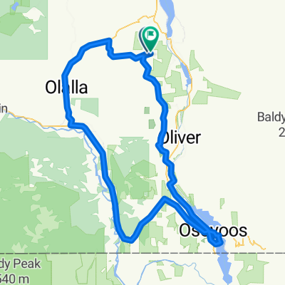
Rd 1 to Rd 22 return on Black Sage and KVR
A cycling route starting in Oliver, British Columbia, Canada.
Overview
About this route
- -:--
- Duration
- 39.6 km
- Distance
- 227 m
- Ascent
- 228 m
- Descent
- ---
- Avg. speed
- 367 m
- Max. altitude
Route quality
Waytypes & surfaces along the route
Waytypes
Cycleway
19.8 km
(50 %)
Road
13.5 km
(34 %)
Quiet road
6.3 km
(16 %)
Surfaces
Paved
9.5 km
(24 %)
Unpaved
0.4 km
(1 %)
Paved (undefined)
6.3 km
(16 %)
Asphalt
3.2 km
(8 %)
Continue with Bikemap
Use, edit, or download this cycling route
You would like to ride Rd 1 to Rd 22 return on Black Sage and KVR or customize it for your own trip? Here is what you can do with this Bikemap route:
Free features
- Save this route as favorite or in collections
- Copy & plan your own version of this route
- Sync your route with Garmin or Wahoo
Premium features
Free trial for 3 days, or one-time payment. More about Bikemap Premium.
- Navigate this route on iOS & Android
- Export a GPX / KML file of this route
- Create your custom printout (try it for free)
- Download this route for offline navigation
Discover more Premium features.
Get Bikemap PremiumFrom our community
Other popular routes starting in Oliver
 oliver tri 2025 route
- Distance
- 39.8 km
- Ascent
- 224 m
- Descent
- 227 m
- Location
- Oliver, British Columbia, Canada
 Richters Pass and the Rollers
- Distance
- 55.4 km
- Ascent
- 556 m
- Descent
- 460 m
- Location
- Oliver, British Columbia, Canada
 Tour of the South Okanagan
- Distance
- 129.7 km
- Ascent
- 1,498 m
- Descent
- 1,508 m
- Location
- Oliver, British Columbia, Canada
 Route to Penticton
- Distance
- 46.7 km
- Ascent
- 855 m
- Descent
- 815 m
- Location
- Oliver, British Columbia, Canada
 Twin Lakes loop DRAO
- Distance
- 30.6 km
- Ascent
- 505 m
- Descent
- 507 m
- Location
- Oliver, British Columbia, Canada
 Oliver - Golden Mile
- Distance
- 39 km
- Ascent
- 223 m
- Descent
- 445 m
- Location
- Oliver, British Columbia, Canada
 OK Falls Old Golf Loop
- Distance
- 69.4 km
- Ascent
- 645 m
- Descent
- 652 m
- Location
- Oliver, British Columbia, Canada
 From Oliver to Penticton
- Distance
- 46.2 km
- Ascent
- 777 m
- Descent
- 722 m
- Location
- Oliver, British Columbia, Canada
Open it in the app