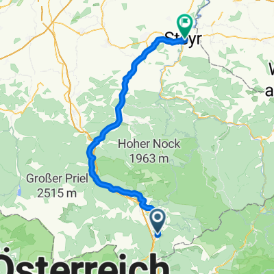
Kalkalpen - part 2
A cycling route starting in Rossleithen, Upper Austria, Austria.
Overview
About this route
- -:--
- Duration
- 112.3 km
- Distance
- 2,933 m
- Ascent
- 3,265 m
- Descent
- ---
- Avg. speed
- 1,310 m
- Avg. speed
Route quality
Waytypes & surfaces along the route
Waytypes
Undefined
112.3 km
(100 %)
Surfaces
Undefined
112.3 km
(100 %)
Continue with Bikemap
Use, edit, or download this cycling route
You would like to ride Kalkalpen - part 2 or customize it for your own trip? Here is what you can do with this Bikemap route:
Free features
- Save this route as favorite or in collections
- Copy & plan your own version of this route
- Sync your route with Garmin or Wahoo
Premium features
Free trial for 3 days, or one-time payment. More about Bikemap Premium.
- Navigate this route on iOS & Android
- Export a GPX / KML file of this route
- Create your custom printout (try it for free)
- Download this route for offline navigation
Discover more Premium features.
Get Bikemap PremiumFrom our community
Other popular routes starting in Rossleithen
- 2025_05-13_Kniewas-Höss
- Distance
- 29.3 km
- Ascent
- 1,431 m
- Descent
- 1,289 m
- Location
- Rossleithen, Upper Austria, Austria
- 2025_05_09_Spital am Pyhrn-Liezen-retur
- Distance
- 34.5 km
- Ascent
- 863 m
- Descent
- 863 m
- Location
- Rossleithen, Upper Austria, Austria
- Hinterstoder - Hütterer Höss
- Distance
- 23.1 km
- Ascent
- 267 m
- Descent
- 1,086 m
- Location
- Rossleithen, Upper Austria, Austria
- Steyrtal-Radweg St. Pankraz-Leonstein-retour
- Distance
- 49 km
- Ascent
- 593 m
- Descent
- 642 m
- Location
- Rossleithen, Upper Austria, Austria
- Enghagen - Gowidlalm - Schwarzkogel - Veichteltal
- Distance
- 66.7 km
- Ascent
- 2,386 m
- Descent
- 2,441 m
- Location
- Rossleithen, Upper Austria, Austria
- Langfirst
- Distance
- 27.6 km
- Ascent
- 884 m
- Descent
- 821 m
- Location
- Rossleithen, Upper Austria, Austria
- 2025_Stummerkogel
- Distance
- 6.6 km
- Ascent
- 231 m
- Descent
- 231 m
- Location
- Rossleithen, Upper Austria, Austria
- 2025_05_02_ Hengstpass-Buchauersattel-Pyhrnpass
- Distance
- 106 km
- Ascent
- 3,012 m
- Descent
- 3,011 m
- Location
- Rossleithen, Upper Austria, Austria